Guiding the conservation of food tree species in Burkina Faso with a threat-mapping approach
Guiding the conservation of food tree species in Burkina Faso with a threat-mapping approach
Notice: Undefined variable: id_overview in /home/ft4user/foreststreesagroforestry.org/wp-content/themes/FTA/template-parts/content.php on line 64
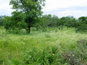
Shea tree (Vitellaria paradoxa) in agroforestry parkland. Photo by H. Gaisberger/Bioversity International
Posted by
FTA COMMUNICATIONS TEAM
A shea tree in agroforestry parkland. Photo by H. Gaisberger/Bioversity International
Agroforestry parklands are among the most widespread traditional land-use systems in sub-Saharan Africa, where scattered individual trees occur on cultivated fields. Over the last decades, agroforestry parklands in Burkina Faso have come under increasing demographic and climatic pressures, which are threatening indigenous tree species that contribute to rural households’ income and nutrition.
In a paper published in PLOS ONE, FTA researchers from Bioversity International and the World Agroforestry Centre analyzed 16 important food tree species in Burkina Faso and six key threats to them: overexploitation, overgrazing, fire, cotton production, mining and climate change. This analysis is crucial to plan for timely and more selective and efficient conservation actions.
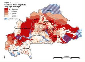
Figure 2: Combined threat magnitude levels ‘high’ and ‘very high’ for all species across all threats and protected areas. Photo by H. Gaisberger/Bioversity International
Our species-specific threat model, developed with national and international partners, combines freely accessible datasets, species distribution models (SDMs), climate models and expert survey results. The model is able to predict, at a fine-scale, where multiple threats are likely to have a negative impact on the availability of suitable habitat in the present and near future. This approach helps to determine which threat contributes most to high-threat levels in certain areas of the country. This is fundamental to guide specific conservation actions such as ex situ conservation, active regeneration and tree planting.
We have found that all 16 species face serious threats throughout much of their distribution in Burkina Faso, and that climate change is predicted to be the most prevalent threat in the long term, whereas overexploitation and cotton production are the most important in the short term.
More than 55% of the distribution of ten of the species is under high or very high threat (Figure 2). Conservation plans – prioritizing the species and if possible, the populations, that are most important to local people – should be urgently developed.
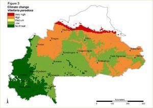
For example, Vitellaria paradoxa, a multipurpose tree with a wide range of food and medicinal uses, is very highly threatened by climate change along its northern margin (Figure 3). Valuable seed sources in this area may be lost unless seed is collected for planting in more suitable climate and/or for ex situ conservation. Populations highly threatened by overexploitation in the central part of Burkina Faso should be prioritized for assisted regeneration as they grow in areas where predicted future climate would produce suitable habitat.
Figure 3: Threat magnitude levels of ‘Climate change’ for shea tree. Photo by H. Gaisberger/Bioversity International
Knowing the regions where threats are most serious allows decision-makers to plan actions at the population level to maintain the genetic diversity across the species’ distribution range. High genetic diversity is important to ensure growth and resilience to site conditions now and in the future.
In the same way, recommendations can be derived from threat maps of the other selected food tree species such as Parkia biglobosa,Adansonia digitata,Boscia senegalensis and Detarium microcarpum.
This approach can be easily used with other species and in other countries, and applied at different scales, from local to continental level, as long as appropriate spatial data and knowledgeable experts are available.
Using maps to visualize threats and their predicted impact is very powerful – it makes results easily accessible and understandable to decision-makers from private and public agencies, who can take action to conserve vulnerable species.
The GIS threat layers to create the threat maps are accessible on Dataverse.
This study was carried out within the framework of the project ‘Threats to priority food tree species in Burkina Faso: Drivers of resource losses and mitigation measures’, financed by the Austrian Development Agency (ADA) and through contributions from the CGIAR Research Program on Forests, Trees and Agroforestry (FTA), which is supported by CGIAR Fund Donors.
Forests, people and data: Participatory monitoring for REDD+ put to the test
Forests, people and data: Participatory monitoring for REDD+ put to the test
Notice: Undefined variable: id_overview in /home/ft4user/foreststreesagroforestry.org/wp-content/themes/FTA/template-parts/content.php on line 64
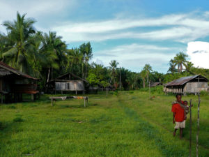
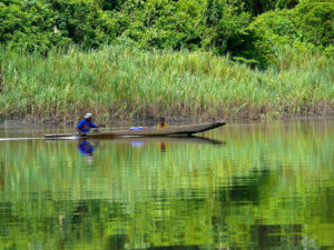
A villager paddles back to shore in Papua. Photo by Manuel Boissière for CIRAD and CIFOR
Posted by
FTA COMMUNICATIONS TEAM
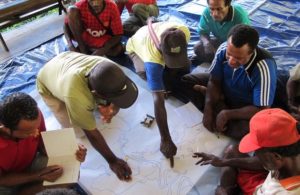
Landscape features, land use and land cover can be identified using participatory mapping through focus group discussion such as this one in Papua, Indonesia. Photo by Manuel Boissière/CIFOR
Growing up in a village in Indonesia’s Central Java in the 1980s, Dian Ekowati went to the local Posyandu health services post every month.
At the community primary healthcare center, her height and weight were recorded and reported to the government by local healthcare volunteers called kaders. One of those kaders was Ekowati’s mother, who volunteered there for years, receiving only a tiny stipend in exchange for her labor — just enough to pay her bus fare.
The Posyandu program was established in 1984 by then Indonesian president Suharto to promote immunization and nutrition, and to address the high child mortality rate — and it was extraordinarily successful. By 1990, there were 250,000 posts in communities throughout the archipelago, and many still operate today.
Years later, as part of a team of researchers at the Center for International Forestry Research (CIFOR) under the CGIAR Research Program on Forests, Trees and Agroforestry, Ekowati realized the Posyandu system could provide useful lessons for REDD+. The UN-backed scheme aims to motivate tropical countries like Indonesia to reduce deforestation and forest degradation, as a way to combat climate change.
Protecting forests and child health? The connection may not be obvious. But before communities can be compensated for emissions reductions, it’s necessary to measure, report and verify their activities, a process known as MRV.
With most REDD+ initiatives taking place in remote areas, and limited funding available, it’s been proposed that forest communities themselves participate in this monitoring. It’s likely to be cheaper than sending in outside experts, could increase transparency, and could make communities feel more empowered and engaged in REDD+.
But it is feasible? What are the challenges? What still needs to be worked out?
Those are some of the questions addressed by a series of 12 papers that form a new special collection in the scientific journal PLOS ONE. Together, the authors assess the feasibility of participatory monitoring (PMRV) for REDD+ from a broad range of perspectives, from social science to governance to remote sensing.
From the technical side, PMRV is definitely doable, says Martin Herold, a CIFOR associate from the University of Wageningen, and a guest editor of the collection. He says new technologies have made it possible for communities to easily access satellite data on forest change on their mobile phones, check out what’s driving that change on the ground, and feed the information back to authorities.
The studies in the collection suggest adopting PMRV can indeed support the implementation of REDD+, and communities can contribute to monitoring both forest changes and other elements like safeguards and benefit sharing, Herold says. “There is no excuse now not to do it.”
It’s the social aspect of PMRV that still needs more work, says Manuel Boissière, a scientist from CIFOR and CIRAD who coordinated the collection. As a whole, the studies reveal many important considerations that must be taken into account when setting up a PMRV system.
“This kind of research can help provide information about the conditions that need to be addressed in order to conduct PMRV,” Boissière says.
A mother carries a child through a field in Papua. Photo by Manuel Boissiere/CIFOR
MOTIVATE ME
One key question is how to motivate individuals to do the work in the first place.
“Why should a community participate in MRV for REDD+?” asks Boissière. “Do they have time? Do they have the capacity, the resources, the willingness and the interest to do so? If they participate, will it threaten their daily livelihoods if their own activities are causing forest degradation?”
“Motivation is key. You cannot expect communities to participate if they don’t clearly see the interest in it for themselves.”
That’s where the Posyandu study comes in. It formed part of a broader project Boissière and his team carried out in three Indonesian provinces — West Kalimantan, Central Java and Papua.
“One of the interesting things about the Posyandu reporting system is that it’s happening despite very diverse access to networks,” Boissière says. “In Java, people can SMS the data, and they have 3G networks in the villages so they can send it by email.”
“In Papua, they have to take a small canoe to the capital of the district to provide the information. It’s very diverse – but it works.”
Dian Ekowati and Carola Hofstee focused on what motivated the Posyandu kaders to volunteer.
“It might seem really different, participating in health monitoring compared with environmental monitoring, but going deeper, we can see there are a lot of similarities,” she says. “Even with the Posyandu, the community didn’t get on board straight away.”
They discovered communities were very skeptical about the health centers when they were first introduced. Villagers relied on traditional healers, and didn’t believe that regularly measuring children’s height and weight was important.
It took a major promotional campaign by the government to convince people to value the centers and to volunteer. Ekowati remembers being asked to sing a jingle at school about the Posyandu: Aku Anak Sehat (‘I’m a healthy child’).
“It was all over the radio during my childhood,” she says. “The song was so massive that we even had a parody version.”
The researchers found that kaders volunteered because they felt a responsibility to their community and were convinced they were making a contribution. Some had a personal interest in childcare, or joined because they were asked to by a respected person.
In Central Java, people were motivated by religious values, and in West Kalimantan, some volunteered out of village pride — because they would be ashamed if a neighboring village had a Posyandu and they did not.
Many of those motivations could also be encouraged under a REDD+ PMRV system, Ekowati believes.
“We’re not necessarily sure that PMRV for REDD+ will work in Indonesia — it’s such a diverse country, with different levels of literacy, access to communication and transportation — but the Posyandu success gives us hope. It was just as hard in the 1980s to ask people to measure children as it is now to ask them to measure trees — so it shows that this is not impossible.”
A villager paddles back to shore in Papua. Photo by Manuel Boissière for CIRAD and CIFOR
LOCALS AND LIVELIHOODS
In another paper featured in the collection, CIFOR scientist Indah Waty Bong and colleagues set out to analyze local drivers of deforestation and forest degradation, and their relationships to community members’ livelihoods.
Remote sensing technologies can show where deforestation is occurring, and how quickly — but local people can give important insights into the reasons why it’s happening.
However, in some cases, the deforestation may be driven by the everyday livelihood activities of those same people — such as harvesting timber, or clearing trees for swidden agriculture.
That means proponents of REDD+ initiatives need to investigate and understand those connections if they are going to ask local people to participate in monitoring, Bong says.
“If you want to address a particular driver of deforestation and the majority of households in that village have it as their main livelihood, then you are talking about something that will have a big opportunity cost – and they may be less willing to be involved in monitoring.”
There is also the potential for conflict, if one group of people are asked to monitor and report on activities carried out by other members of the community. “From a project perspective that’s an ethical issue you need to think about,” Bong says.
A key finding was that the local processes behind forest cover change are dynamic, and vary both between and within communities. A driver — such as logging — might be responsible for a relatively large area of forest degradation, but only provide income for a small proportion of the community.
That means interventions and incentives can be targeted directly at those people, ensuring greater fairness and efficiency, Bong says.
Participatory MRV is in part motivated by the need to ensure the interests of local people are fairly represented in REDD+. To ask a community to participate, you need to be clear about who exactly you are talking about, Boissière says.
In another paper in the collection, CIFOR scientist Stibniati Atmadja investigated how researchers have assessed ‘community perceptions’ of REDD+.
“You can’t be everywhere at the same time — you have to sample, and then generalize to a bigger area,” she says. “So research on community perceptions involves fundamental choices about how to represent heterogeneous communities.”
That’s fine, Atmadja says, as long as authors explain what those choices were and why they made them.
“Most academic papers we looked at did not really give readers enough information to answer the simple questions: Who did you sample? What does your sample represent?
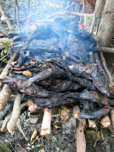
Fish are grilled on a woodfire in Kay village, Papua. Photo by Manuel Boissière for CIRAD and CIFOR
The study did not analyze websites, newsletters and advocacy material — which are disseminated more widely than academic research — but these sources are even less likely to provide information about their sampling methods, Atmadja says.
“They say, ‘we went to the field, we met with local people’ — well, which part? The easiest part to get to? Which people — those who were already disenchanted? How much can you really generalize based on those people’s perceptions?”
Both researchers and non-researchers can and should do better, she says. This matters because REDD+ initiatives tend to happen in remote areas, in forests that can be hard to reach.
“The few voices that do come out carry a lot of weight — so it’s important to be mindful of that,” Atmadja says.
NO ONE RECIPE
As a whole, the collection shows the need for embracing diversity when it comes to designing PMRV systems for REDD+.
“Even in one country, there is not one recipe for engaging local communities,” Boissière says. “People don’t have the same activities, they don’t depend in the same way on forest products, or have the same access to roads or infrastructure. You really need to develop something which is adaptive.”
It seems PMRV can work at the local level, he says, but to be successful, the next step is figuring out how to scale it up into a system that works at multiple levels of governance.
“You need to have a consistency in the kind of data that communities collect, and then come up with a way to merge it into a national system.”
Practitioners also need to acknowledge that it may not work everywhere.
“Any project or government program that wants to increase local participation in REDD+ or MRV should conduct a preliminary study looking at why they should engage this community in that place,” Boissière says.
“From there, they can understand whether it’s worth pursuing, and design something to engage with them – or whether it’s better to send a team of experts instead.”
There are many hurdles to overcome — but this comprehensive new body of detailed research lays the foundations for putting participatory MRV into practice.
By Kate Evans, originally published at CIFOR’s Forests News.
This work forms part of the CGIAR Research Program on Forests, Trees and Agroforestry. We would like to thank all donors who supported this work through their contributions to the CGIAR Fund.