In recent years, drones have been flying in a fast-moving cloud of enterprise, both on the part of developers and of researchers figuring out how to best put these devices to use in their sectors, including in forestry and landscape management.
In 2012, peer-reviewed journal Tropical Conservation Science ran an article announcing the ‘dawn of drone ecology,’ hailing the aerial technology as an alternative to satellite remote sensing mapping, with competitive cost and photographic advantages. Since then, the buzz around drones has grown steadily louder.
As with all disruptive technology, there are pros, cons, ethical questions and promising horizons surrounding the use of drones in forest landscape research. The Center for International Forestry Research’s (CIFOR) Forests News sat down with Principal Scientist Yves Laumonier – a CGIAR Research Program on Forests, Trees and Agroforestry (FTA) scientist and CIFOR’s foremost drone ecologist – to gain some insight into the situation.
How did you first become interested in using drones?
My university background is in plant ecology and vegetation mapping, but I am also a pilot of small planes. I love to fly and see the earth from the air; it is the best way to apprehend a landscape. Drones seemed so much adapted to large-scale land cover mapping – something to substitute in for our old days of aerial photography, which has been completely replaced by the use of satellites.
When did you first use a drone?
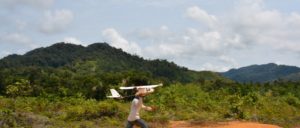
It was in 2016, in Kalimantan, Indonesia. At the beginning it was not easy to convince people at the office. It was more a private initiative. But once we showed the results, people become a lot more enthusiastic.
Our first test flights were close to the border with Malaysia, and I was very nervous because a lot of military are stationed there. We went to explain what we were doing so the drone wouldn’t be shot down. But they were like children with a toy and offered to let us use their helipad.
We went back in 2017, to monitor the dynamics of the landscape and could see which fields they burned for crops since 2016. We will go again this October. If we do this every year for some time, it will make a very nice study. In the meantime, we will write a paper about the method we use to do photo-mosaicking, measuring biomass of trees and other structural parameters of the vegetation. We are also starting a project on trees outside of forests and specifically on farms, and here again drones have huge potential to see isolated trees and small patches that satellites cannot always properly estimate.
Read more: Drone technology for science
How large an area can a drone cover?
With the type of drone we use, we do about 2,000 to 4,000 hectares in one mission. It takes between three and four days to one week, depending on weather. If it’s windy or rainy, you cannot fly.
What are the advantages of drones over satellites?
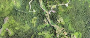
Their advantage for me is to be able to monitor very complex matrix landscapes, such as traditional swidden and forest landscapes, or places with intense fragmentation of habitats and small plot agriculture. In many agriculture systems, trees on farms are often just hedge rows. But for the Dayak communities for instance, in Kalimantan, it is a very complicated mixture of fallows, mixed garden, rubber and forest patches. Most satellites cannot make distinctions because of the resolution (10 to 30 m), but with a drone, we can properly map the fine grain pattern of these landscapes. You can use higher-resolution satellites, but it’s always very expensive and often very difficult to get the data.
Cloud cover is also a big issue with satellites. In the humid tropics, sometimes you get one good image of an area per year, and sometimes none. So drones came up as a potentially nice tool because you can avoid the cloud cover.
Also, if I am checking a vegetation map and am not sure about the forest or vegetation type, I used to spend maybe one day to check it by foot, but now I can send the drone, and in 20 minutes, I know. So that’s very, very useful. And at the same time you can get very nice and dramatic pictures of village community life.
But, I do not want to say that drones should replace satellites. There are a lot of free satellite imageries – Landsat, and now a new one called Sentinel. The weakness so far for drones is that they cannot cover as huge an area. I was asked once if drones can map oil palm, and I asked, ‘Yes, but why? With satellite, it’s enough.’ Plantations are so large that it’s not really necessary, unless a concession owner wants to know where there’s a sickness in his palm trees, to know where leaves are yellowing or something is wrong. Drone data can be used to calibrate satellite data.
What are the reactions of local communities when you come in with a drone?
We do a lot of participatory mapping at CIFOR and have in the past come up with sketch maps together with communities – it’s nice! But we were thinking the drone would give more realistic, to-scale results. And we found that communities very quickly understand the photo mosaic maps, because they know the landmarks, the rivers. So with their consent we produce these maps and then bring them back to discuss and conduct more ground-checks, and then we have a proper at-scale map that’s much better than a sketch map. We show them to local governments, and so far everyone likes them because they are much better than those before, especially if you need to give this document a legal status.
Is there dialogue between the research and tech communities about drone development?
Completely, especially in agriculture… Maybe more than in forestry, people saw the incredible potential for drones in agriculture monitoring. Farmers have started to use drones to monitor the health of their crops, and people who produce drones are very much in touch about this.
The technology is going so fast. Now you have companies doing drones for all purposes you can imagine – archaeology, geology, construction, urban landscapes, volcano monitoring. There’s so much competition, and the tool is becoming very good. I think soon we’ll have more drones with exactly the same sensors as satellites – infrared, Lidar. Lidar is a super tool for carbon measurement, and I just saw a mini Lidar is coming on the market. Maybe we will try to put it on our drone.
In terms of risks, in what context are drones of most concern: while you’re using them in the field, or afterward, when you publish your findings?
I think both. In the field, so far we’ve had no problem because we get proper introductions and permits from communities and local government. But we were not in areas where you have potential conflict between companies and communities. We did fly and see illegal mining and illegal logging for instance. I met the loggers in the forest, and they didn’t ask questions – the drone was high enough you couldn’t hear, among the noise of their chainsaws…
Already with satellites you deal with conflicts between national parks and local villages. When you show the data, it can be a big risk. Or gold mining in Kalimantan, which means sucking up the banks of the river – some areas are deserts of white sand now that cannot be rehabilitated. Companies might be really unhappy for us to show details of their operations.
Ethically, are you obligated to publish your findings anyway?
I would be inclined to do so, yeah. I feel we need as independent scientists to show what’s happening, looking at degradation of the environment and so on. It’s important we keep doing so. I think we should be completely free to publish what we find for evidence.
What’s your dream drone?
A drone that could collect leaves from trees for me. It’s always a burden. For species identification, you need to collect from trees that are 60 meters high, so we use tree climbers, but I’m always afraid the person will fall. And if researchers can’t get locals to climb trees and only come back with local names of species, it means little and can lead to a wrong assessment of diversity and species distribution. I’ve used monkeys, and it was great, but you will end up with animal activists after you. We really need drones that can collect twigs and leaves for us in the canopy.
By Gabrielle Lipton, originally published at CIFOR’s Forest News.
For more information on this topic, please contact Yves Laumonier at Y.Laumonier@cgiar.org.
This research forms part of the CGIAR Research Program on Forests, Trees and Agroforestry, which is supported by CGIAR Fund Donors.