Notice: Undefined index: id in /home/ft4user/foreststreesagroforestry.org/wp-content/themes/FTA/template-parts/content.php on line 3
  • Home
  • Long-term relationships and mutual trust—partnerships and research on climate change

Long-term relationships and mutual trust—partnerships and research on climate change


Notice: Undefined variable: id_overview in /home/ft4user/foreststreesagroforestry.org/wp-content/themes/FTA/template-parts/content.php on line 64
Not only in Ethiopia, climate change research partnerships worked well. Photo: Ollivier Girard/CIFOR
Posted by

FTA

Photo: CIFOR
Photo: CIFOR

By Christopher Martius, Coordinator of the Flagship on Climate Change Adaptation and Mitigation of the CGIAR Research Program on Forests, Trees and Agroforestry (FTA).

For our research on climate change, we have proof that our partnerships do work – there is strong evidence from last year’s assessment of the Global Comparative Study on REDD+, which was about our partners in different countries who did research with us.

Very often, national partners – from universities, NGOs and other organizations – work using the same methodology, each one in their country. Those that are new to the approach will get some training. We are thus able to apply the same methodology across countries and to compare the results.

Often in this process, partners improve their capacity and you can see that they raise their national profile. This model of cooperation is successful, and we call this the co-production of science model.

Good examples of this model are our links with: the Wondo Genet College of Forestry in Ethiopia and the Ethiopian Environment and Forestry Research Institute. In Vietnam, we collaborated closely with the Centre of Research and Development in Upland Areas (CERDA), an NGO; and in Peru, we with worked a private consultancy, Libélula Comunicación Ambiente y Desarrollo, and analyzed media coverage of REDD+ in the country. And we have many more best practices like this.

Not only in Ethiopia, climate change research partnerships worked well. Photo: Ollivier Girard/CIFOR

Of course, we also have many partnerships with universities in Europe, the US and in Australia. As Flagship 4, we maintain a long-standing relationship with the University of Wageningen, where we regularly send students from developing countries to study for PhDs.

We have similar arrangements with the Agricultural University of Ås in Norway, currently there is one student from Zambia and one from Ethiopia studying there. We work with several universities in the US such as Oregon State and North Carolina State. I am linked to the Center for Development Research (ZEF) at the University of Bonn, Germany. And these partnerships are expanding.

Under FTA, researchers created Terra-I, a tool that provides Global Forest Watch with local data. This was led by  the International Center for Tropical Agriculture (CIAT). A good example for a partnership in the political sphere can be found in the LUWES/LUMENS collaboration with governance institutions in the Indonesian provinces.

We have developed strong ties with GIZ (Gesellschaft für Internationale Zusammenarbeit) in Kenya, Indonesia and Tajikistan. In Kenya, we collaborate on the so-called water tower project, in Indonesia on agroforestry and in Tajikistan the link is forestry and migration. These partners appreciate this collaboration as it brings input from our research efforts into their work.

I look forward to new partnerships, with the International Institute for Applied Systems Sciences (IIASA)’s GLOBIOM for example – a global model to assess competition for land use between agriculture, bioenergy and forestry. This will be about developing scenarios for specific forest sites. We also plan to develop a new collaboration with Lancaster University in the UK, again on the water towers project in Kenya.

The partnerships that work well are the ones who continue over a long time. There is mutual trust and this helps us to work together even in rougher times. FTA Phase II has a duration of six years – I think we can achieve a lot in this time!


Notice: Undefined index: id in /home/ft4user/foreststreesagroforestry.org/wp-content/themes/FTA/template-parts/content.php on line 3
  • Home
  • Research impact and partnership: Using data to take decisions in Turkana County, Kenya

Research impact and partnership: Using data to take decisions in Turkana County, Kenya


Notice: Undefined variable: id_overview in /home/ft4user/foreststreesagroforestry.org/wp-content/themes/FTA/template-parts/content.php on line 64
Posted by

FTA

shared-screenshot
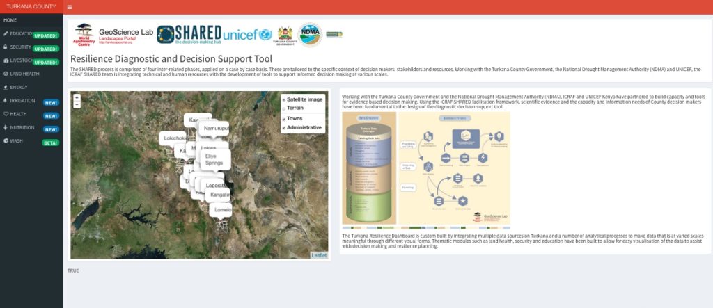
What if governments and parliamentarians had a way of knowing where their citizens needed what exactly, what condition the land was in and where to put their money most efficiently to most effectively address multiple issues simultaneously? Spatial scientists at the World Agroforestry Centre (ICRAF) are supporting the county government of Turkana, Kenya in doing exactly that.

But let’s start at the beginning. In 2012, ICRAF launched the Landscape Portal, an interactive open-source website to allow users to get easy access to big data sets and select data to create maps. These big data sets were collected under the Sentinel Landscapes project of the CGIAR Research Program on Forests, Trees and Agroforestry (FTA).

ICRAF researchers are constantly striving to make their research data accessible and valuable to decision-makers, whether in communities or at national and global levels. This is how the idea of SHARED, short for Stakeholder Approach to Risk Informed and Evidence Based Decision Making, emerged.

SHARED operates in Kenya through a partnership between the Turkana County Government, the National Drought Management Authority (NDMA), UNICEF Kenya and ICRAF.

In 2010, the new Kenyan constitution devolved power to county governments and each county developed a County Integrated Development Plan (CIDP). The Turkana Government approached ICRAF and UNICEF and asked them for help in designing tools for planning and budgeting in order to enhance people’s resilience and reduce the incidence of emergencies. Funding from USAID made the Turkana SHARED project possible.

Setting SHARED up

At first, it was necessary to bring together all of the existing data from local and national sources, which came in different forms such as handwritten or typewritten reports, photographs or survey results. The data had to be sorted and digitized so that they then could be visualized spatially.

UNICEF Kenya brought in their experience in community engagement and data management to track progress on key socioeconomic indicators including education, health, nutrition, water and sanitation. The NDMA also provided information from their regular drought monitoring of county sentinel sites.

A major component of the work was the development of a spatial dashboard to house all the data and allow decision-makers to interact with and query the data. The design of the platform took place using a collaborative process of capacity development with the Turkana County Government.

This means that key staff at the government’s Finance and Planning Unit and other county executives had to be trained, for example in three workshops.

“They learned how to interpret spatial evidence to prioritize budget allocations, based on actual need,” says ICRAF’s Geoinformatics Senior Scientist, Tor-Gunnar Vagen, who has led the technical development of the spatial dashboard. “We call it the resilience diagnostic toolbox.”

In the first phase of development, the SHARED Turkana dashboard shows data for different sectors such as education, nutrition, sanitation, irrigation, security, or land health.

Vagen tells us that the tool allows the government to see for example every single school in its county with trends of teacher-student ratios and enrolment of boys and girls.

“It also shows all the security incidents in the county in a given year and where the hot spots were. This could be violence, protests or cattle rustling.”

land-health-turkana
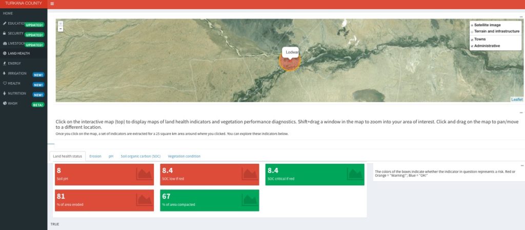
For land health, the system is so advanced that one can click on a map, and it zooms into the location and runs different types of analyses. The map is complemented by colored boxes – like a traffic light – with red indicating a risk in that zone such as high pH, low carbon or high erosion (see screenshot).

Surprising results on HIV/AIDS

“This is where we have interaction with the county and how we try to support the county with science,” Vagen says and gives the example of the HIV/AIDS data.

“The map shows that the highest number of health facilities is in central Turkana, but the number of children with HIV/AIDS there is quite low. In the western part of the county, however, close the border with Sudan where a lot of refugees are coming through, the HIV prevalence is very high.”

So you can look at where children with HIV/AIDS get actual care in Turkana and this is not where the prevalence is high. With better data, the government and key development partners such as UNICEF can better target their interventions.”

“In Kenya almost 8 out of 10 children are subjected to deprivation in at least one of the key pillars of child well-being such as access to water, good nutrition, education, health or access to social services,” says Ousmane Niang, Chief of Social Policy of UNICEF Kenya.

“For the government and its partners in Turkana County, it is absolutely important to easily access real-time data and evidence for informed decision- making. Therefore SHARED will be a milestone in supporting the county in planning, budgeting and strengthening service delivery,” he adds.

“Partnerships and collaborations such as SHARED are the key to delivering impactful results for adolescent, children and youth.”

Taking SHARED to the next level

A joint proposal for the second phase of work is currently under review at USAID. “The idea is that we will advance the capacity to interpret and manage in the county,” says Vagen.

“In the future, it will be the county’s data, managed in their knowledge management center so that the platform can be updated, interpreted, and evidence can be shared to support decisions.”

The SHARED team would like the platform to eventually act as an early warning system for hazards and to track epidemics. In order to function like that, it will need to have an SMS-based reporting system that will more rapidly connect community experiences with county government decisions. When it is finalized, the dashboard will deliver data in real time and be able to update itself.


Notice: Undefined index: id in /home/ft4user/foreststreesagroforestry.org/wp-content/themes/FTA/template-parts/content.php on line 3
  • Home
  • Project news: Engaging citizen scientists to secure fresh water in Kenya

Project news: Engaging citizen scientists to secure fresh water in Kenya


Notice: Undefined variable: id_overview in /home/ft4user/foreststreesagroforestry.org/wp-content/themes/FTA/template-parts/content.php on line 64
Posted by

FTA

IMG_4014Originally published at Center for International Forestry Research (CIFOR)

Water is life, so they say.

Ensuring everyone has enough water is especially important in countries with high poverty rates and which are undergoing rapid economic development. Land use change can put stress on water availability and quality, as it has done in Kenya with the large-scale loss of forests.

Monitoring water in such contexts is essential. A new project under the CGIAR Research Program on Forests, Trees and Agroforestry (FTA) is aiming to do just that, with the support of the German Federal Ministry for Economic Cooperation and Development (BMZ) and the GIZ Advisory Service on Agricultural Research for Development (BEAF). 

The two-year project contributes to FTA research on biodiversity and ecosystem services. By developing simple, low-cost methods to monitor water across landscapes, this work provides an opportunity to value ecosystem services and implement land-use planning measures that preserve the most world’s most precious resource.

“There is an increasing demand for water for direct human and livestock consumption and for the production of agricultural and industrial products. Water abstraction plans are not sustainable without knowing how much water is available across seasons, and its quality,” said Mariana Rufino, previously a senior scientist with the Center for International Forestry Research (CIFOR) and now with the University of Lancaster, UK.

Rufino is leading the second phase of a project that started early in 2016 and which extends to 2018. It aims to ensure sustainable water management in a place that is experiencing many pressures on water availability.

Involving citizens

They are also putting theories of water monitoring into practice. These theories include the importance of incorporating local residents – who are experts on native water reserves – by turning them into citizen scientists actively engaged in observing and analyzing their liquid resources.

“The villagers are eager to get involved. They have seen the water levels in their streams changing rapidly, and some people are concerned about the changing color of the water, which has become brown from large amount of sediment. We’ve explained that while the large amount of sediment indicates the region is losing its valuable soil capital, the most dangerous water pollutants are not actually visible,” Rufino said.

The first phase of this joint project by CIFOR and Justus Liebig University in Germany began in 2014 in Kenya’s Sondu River basin. Water gauges, which were old and in disrepair, were updated and replaced, and local water users were trained to monitor water levels, including reading the gauges and reporting via mobile phone to an online database.

“These water users are at the same time our citizen scientists. Being part of the research makes water users feel responsible. Ideally, this raises awareness of water as a precious resource and they hopefully carry this message to their communities,” explained Lutz Breuer, a professor for landscape, water and biogeochemical cycles at Justus Liebig University who is contributing to the work.

BMZ and GIZ BEAF are providing new financial support for the 2016–2018 phase, which continues to address the pressure on water availability that Kenya is facing. Valuable water monitoring work will be extended by expanding the network of sites and citizen scientists collaborators, and by placing signs next to gauges to encourage the participation of all residents.

“Thanks to this collaboration, we are testing what works for the water manager and water user needs. Our findings are going to be crucial to advise future upgrading of water monitoring in Kenya and hopefully in the East Africa region through the water program of GIZ,” Rufino said.


Back to top

Sign up to our monthly newsletter

Connect with us