FTA Highlight No. 3 - Conservation of Tree Biodiversity and Sustainable Forest Management
FTA Highlight No. 3 – Conservation of Tree Biodiversity and Sustainable Forest Management
Notice: Undefined variable: id_overview in /home/ft4user/foreststreesagroforestry.org/wp-content/themes/FTA/template-parts/content.php on line 64
Posted by
FTA communications
Millions of people in the tropics derive benefits through the management of tree species diversity, and from the genetic variation within these species, in forests and farmland. People depend on trees for food, medicine, fuel, tools, fodder for livestock and shade.
Conserving and sustainably managing forest biodiversity, including forest genetic resources (FGRs), is critically important. Trees provide ecosystem services such as soil and water conservation, carbon sequestration, pollination, and mitigation of the effects of natural pest predators.
Insights on diversity are critical to understanding the domestication and dispersal of tree species, managing their genetic resources and setting conservation priorities.
Previously, conservation of FGRs centred on in situ approaches, and in particular in national parks and forest reserves. The design and location of these conservation areas are rarely driven by genetic principles. FTA has characterized the genetic diversity of tree species to assist both conservation actions and sustainable management.
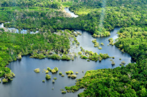
Data on tree species supports management of FGRs and resilient forest landscapes, including in the Amazon.
As part of “FTA’s highlights of a decade,” a new series focusing on the programme main results since inception in 2011, FTA is now publishing the volume on Conservation of Tree Biodiversity and Sustainable Forest Management. The publication outlines the relevance and impact of FTA’s work in this research domain at the global level and how it contributed to shape some of the key stakeholders’ agendas.
It illustrates how FAO’s Global Plan of Action to implement a global monitoring system for FGRs benefitted from FTA’s support, integrating our analysis of vulnerability of tree species. FTA also contributed to FAO’s State of the World’s Biodiversity for Food and Agriculture. Biodiversity’s role in supporting both environmental and dietary sustainability are summarized in a global report.
As a result of FTA’s work, the 12th Conference of Parties to the Convention on Biological Diversity (CBD) called for increased attention to native species and their genetic diversity in conservation and restoration.
FTA scientists have also designed various approaches to track forest degradation. Although the issue receives considerable global attention in policy processes, there is no generally accepted way to define or measure it. FTA provided better understanding of the complex dynamics at play, paving the way for improved policies to address the phenomenon at different scales.
Participatory monitoring approaches reviewed by FTA scientists found that information produced through collaborative learning was used more often in decision making related to forest management than evidence-based information was.
The publication discusses a number of case studies and arguments for better understanding FGRs in the global context.
FTA’s work in Guatemala in community forestry has shown it can reconcile management with conservation of both forests and FGRs, while providing livelihood benefits. In Burkina Faso research has shown how gender norms affect tenure patterns related to the highly valuable tree species Parkia biglobosa or néré. FTA researchers also studied how to increase women’s participation in inclusive management of native fruit trees in Malaysia and India.
In northwestern Peru and southern Ecuador, local ecological knowledge showed great potential in selecting tree species that need to be conserved or restored. Collaborations with local and indigenous people have been critical in understanding biodiversity dynamics at the intraspecific level.
Although adequate genetic diversity is a precondition for successful forest landscape restoration (FLR), restoration projects worldwide typically use seed and seedlings of limited genetic diversity. FTA provides tools for better better integrating FRGs in FLR.
The publication illustrates the relationships between biodiversity and ecosystem services, and between biodiversity and carbon. It points to how trees on farms (TonF) make a critical contribution to biodiversity conservation in agricultural landscapes, especially with the current shift from collection of NTFPs to agroforestry systems, which requires an assessment of all the benefits that rural people obtain from various tree species.
Finally, the publication analyzes the links between logging (selectively managed vs illegal) and forest biodiversity and spotlights the Tropical managed Forests Observatory (TmFO), an FTA innovation that brings together 18 research institutions in a global network that cross-correlates and analyses data from tropical logged forests over 600 sites. The TmFO database helps users understand the long-term effects of deforestation and forest change on ecosystems.
FTA also contributed to setting up the Global Timber Tracking Network, which promotes the use of innovative tools to identify tree species and determine the geographic origin of traded wood, such as analyses of DNA samples from timber to detecting potential illegal logging.
Download the publication to find out more about FTA’s work on biodiversity and how critically important it is to conserve and sustainably manage forest biodiversity (including forest genetic resources, or FGRs) to address climate change issues, food and nutrition security, livelihood opportunities and forest ecosystem resilience.
The results are based on research on the characterization of biomass accumulation potential in secondary forests in Nicaragua and Costa Rica, and the contribution of timber species to this potential.
Scientists from CATIE (Tropical Agricultural Research and Higher Education Center) and the Center for International Cooperation in Agronomic Research (CIRAD), in collaboration with the National System of Conservation Areas (SINAC, its Spanish acronym) of Costa Rica, held the webinar Potential of secondary forests, in which the results of research on the ecological and timber potential of secondary forests in Nicaragua and Costa Rica were presented, as well as the economic and environmental impact they can generate in tropical landscapes.
Marie Ange NgoBieng, a researcher at CATIE’s Forests and Biodiversity in Productive Landscapes Unit who led the research, explained that two-thirds of tropical forests are secondary or degraded and are equally relevant for the ecosystem services they provide, yet they are very vulnerable.
The activity presented the current context characterized by the vulnerability of tropical secondary forests and introduced the potential of these secondary forests to respond to the current challenges of forest systems, mainly in terms of timber supply.
In addition, from the research results presented by NgoBieng, the importance of these forests was concluded: secondary forests effectively sequester carbon from the atmosphere in their biomass, thus contributing to climate change mitigation. Also, the existence of a significant timber potential in secondary forests was highlighted, meaning that the contribution of timber species in the aboveground biomass of the plots is very significant.
“Disseminating these research results provides an extremely interesting and novel scientific basis for the planning and implementation of sustainable forest management in secondary forests, which will contribute to the well-being of producers, post-COVID19 economic revival and climate change mitigation,” said Bryan Finegan, director of Inclusive Green Development Research, who introduced the webinar.
According to NgoBieng, during the event there was an exchange of ideas about secondary forests in Latin America, taking into account not only ecological and timber production aspects, but also other important but less studied ecosystem services, such as the production of medicinal plants and the conservation of native and endemic species, among others. Her presentation is downloadable here.
The webinar, which took place on March 26 with the participation of more than 140 professionals from Mexico, Central and South America, was funded by the Forests, Trees and Agro-forestry (FTA) research program for the development of forests, trees and agro-forestry and its financial partners. Participants in the webinar included researchers, professors, students, politicians and representatives of indigenous institutions.
Marie Ange NgoBieng
Researcher
CATIE’s Unit of Forests and Biodiversity in Productive Landscapes marieange.Ngo@catie.ac.cr
*****
Written by:
Daniel Cedeño Ramírez
Communications Assistant
Information Technology and Communication daniel.cedeno@catie.ac.cr
FTA is the world’s largest research for development program to enhance the role of forests, trees and agroforestry in sustainable development and food security and to address climate change. CIFOR leads FTA in partnership with ICRAF, the Alliance of Bioversity International and CIAT, CATIE, CIRAD, INBAR and TBI.FTA’s work is supported by the CGIAR Trust Fund.
Notice: Undefined variable: id_overview in /home/ft4user/foreststreesagroforestry.org/wp-content/themes/FTA/template-parts/content.php on line 64
The NHSL team of researchers in El Tuma
Posted by
FTA communications
This article is a longform, part of a new series of FTA blogs aiming at providing in-depth analysis of mature FTA projects. By consulting/interviewing all the scientists involved in the study, these longforms give a detailed overview of specific projects, augmented by the comments from the scientists who developed them. This longform is issued in conjunction with International Mother Earth Day 2020.
A peculiar perspective on the first reports from the pioneering Sentinel Landscapes program
We are living in the Anthropocene.
Sometime in the 1950s, it is proposed, we finally broke from 11,650 years of history and entered a entirely new epoch. Rather than glacial advance and retreat, this epoch is defined by the industrial activity of humankind.
Deforestation, soil erosion, construction, river dams and nuclear weapons will leave permanent relics in the stratigraphy of the earth: as deposits in the sedimentary record, as ghostly technofossils, or as lethal fallout signatures.
There are two possible responses – if we rule out burying our heads in the degraded soil – either we wait for nature to overthrow industry or we apply our human ingenuity, so often the curse of ecological wellbeing, to its restoration.
But how can we hope to turn things around if we do not know what is driving deforestation and degradation? Or if we do not know how many trees we have or how quickly they are disappearing? Or if we do not fully understand the consequences we face if forests disappear from the landscape?
To develop interventions that will work, the first step is knowing what is going on there, and for this we need data, credible data, large data, multi-year data.
Medical research has epidemiological studies that monitor large cohorts of the population over long periods of time to track global health and help predict and eliminate disease. What does forest conservation have? Sentinel Landscapes.
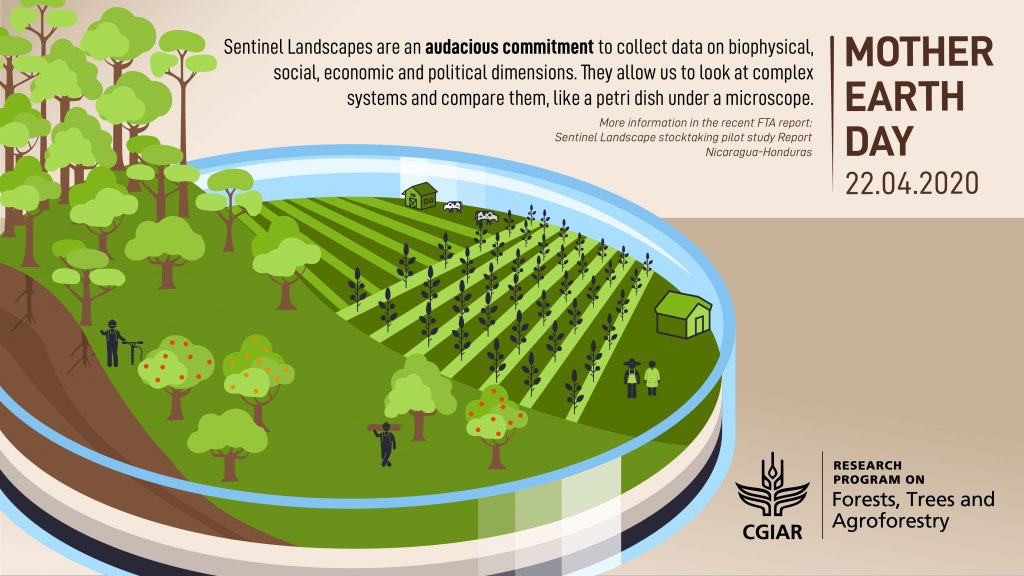
Sentinel Landscapes: A health check for tropical land use
Driven by the Forests, Trees and Agroforestry’s (FTA) program led by the Center for International Forestry Research (CIFOR), the Sentinel Landscapes initiative is an audacious commitment to collect data on biophysical, social, economic and political dimensions across and monitor respective indicators across a network of eight carefully chosen tropical forest landscapes over extended periods of time.
Using the same standardized methodologies, this data promises to provide common ground for comparison – and, crucially, extrapolation. The Sentinel Landscapes program is the global health check that we desperately need so that we can face climate change, land degradation, poverty and food security with clear vision.
The idea for Sentinel Landscapes was hatched during conversations between colleagues at World Agroforestry (ICRAF) and CIFOR in 2011 and 2012. Since those first conversations, more and more academic organizations have joined the FTA program and participated to the Sentinel landscapes initiative, including Agricultural Research for Development (CIRAD), Bioversity International, Centro Agronómico Tropical de Investigación y Enseñanza (CATIE) and the International Center for Tropical Agriculture. In the words of one scientist, it has always been “super collaborative”.
Sentinel Landscapes have now been established across borders in Borneo-Sumatra, the Nile-Congo, Cameroon, the Mekong, West Africa, Western Ghats in India and the Western Amazon. But the first to report, in February 2020, was the Sentinel Landscape of Nicaragua-Honduras.
Sentinel Landscapes combine GIS data with on-the-ground samples and surveys
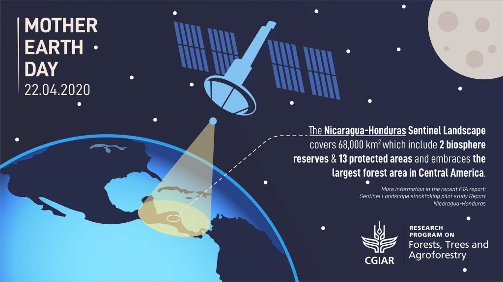
The Nicaragua-Honduras Sentinel Landscape
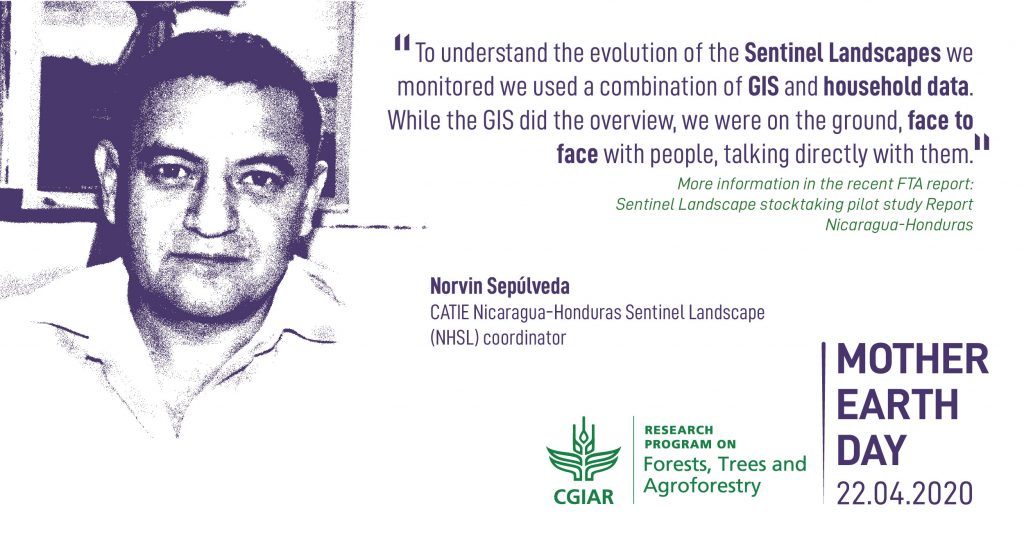
Sentinel Landscape stocktaking pilot study: Report Nicaragua-Honduras [pdf]The lead author of the report is Norvin Sepúlveda at CATIE, who is coordinating the Nicaragua-Honduras Sentinel Landscape (NHSL).
The NHSL is a “mosaic of forests, agricultural land, cattle ranches and agroforestry systems” covering an area the size of the Republic of Ireland or twice the size of the Netherlands.
Straddling the border of two countries, the NHSL encompasses the largest remaining forest area in Central America and hosts at least twelve different ecosystems, including cloud forest, premontane humid tropical forest and pine savannahs.
According to the new report, as well as astonishing botanical and fauna diversity, the landscapes of the NHSL also sustain 822,175 farm families and 21,000 indigenous peoples.
Different kind of “forest transitions” do take place in the area, representing different situations along the “forest transition curve” concept coined by FTA.
Nicaragua is currently plummeting down the “forest transition” curve, with forest cover being lost at an increasingly rapid rate. Meanwhile, Honduras is a late-transition country, with deforestation slowing in whatever small fraction of forests remain.
It would be impossible to survey such a vast territory in its entirety, so as part of the Sentinel Landscapes (SL) monitoring sampling methodology, the NHSL team selected four study blocks, two in Nicaragua and two in Honduras, which each represent different points on the forest transition curve. Each block is 100 sq km.
The concept of the SL was to integrate three different standardized methodologies to collect:
biophysical data
political and institutional data and
socio-economic data.
These harmonized data collection modules were coordinated by the Research Methods Group (RMG) at ICRAF. The work on biophysical methods began in West Africa in 2005, with the research of Tor-Gunnar Vågen of ICRAF
“We chose the four sites using GIS data and a special set of criteria,” Sepúlveda explains, “so that we got a range of different sites and a combination of diverse farm typologies and conservation issues.”
In Nicaragua, the El Tuma La Dalia study block is mountainous terrain, largely cultivated with coffee, but with some pine and cloud forests. Also in Nicaragua, Columbus Mine is less cultivated with staple cereal crops, but has more forest and is known for its tropical humid climate.
Across the border in Honduras, Rio Platáno is primarily forest with little cultivation, whereas the Rio Blanco study block, nestled in a valley, is mostly pasture for livestock with only small pockets of surviving forest.
Beyond case studies: the Land Degradation Surveillance Framework
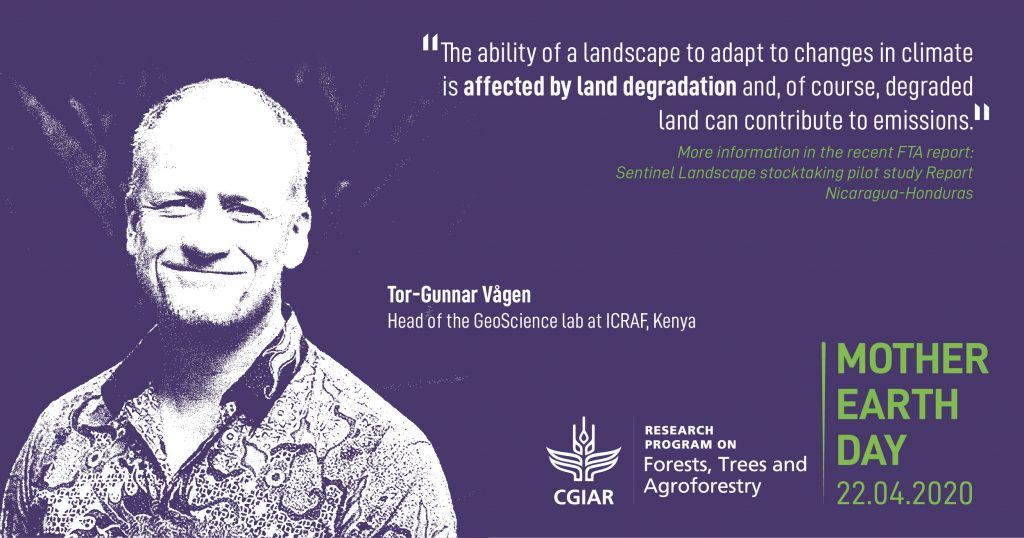
Tor-Gunnar Vågen is now head of the GeoScience lab at ICRAF, based in Nairobi, Kenya. For the past fifteen years, Vågen and soil systems scientist Leigh Ann Winowiecki, have worked to implement the Land Degradation Surveillance Framework (LDSF).
A systematic method for collecting data and measuring land degradation, the LDSF builds up a biophysical baseline that covers key indicators including land use, land cover, land degradation, soil health, topography and impact on habitat..
But the real strength of the LDSF is in its consistency: it can be applied to any landscape and will give standardized and thus comparable data.
Before the LDSF, most forest conservation data was based on case studies that answered a specific question in a specific location. Although very useful, case study data makes it impossible to compare contexts or to generalize, and impossible to answer questions like ‘What role do trees have on farms in different locations and contexts?’ or ‘What is the potential for soil to sequester carbon in different locations and contexts?’
As a standardized, randomized data collection method, the LDSF solves this problem and helps scientists compare and scale up their localized findings into potentially globally-applicable conclusions.
“Applying the same framework and then replicating this across most major ecosystems means we can start answering the bigger questions,” Vågen says. “We can look at the larger patterns.”
At the start of the Sentinel Landscapes program in 2012, Vågen and Winowiecki trained the local field teams in Nicaragua and in Honduras so that data collection would be consistent.
Tracking degradation and climate change
From the biophysical baseline indicators, Sepúlveda, Vågen, Winowiecki and their fellow authors expect the NHSL to suffer badly from the impacts of climate change, particularly when it comes to the flow and contamination of the water supply.
The geographical location of Nicaragua and Honduras make both countries vulnerable to extreme weather events and a pattern of freak rainstorms alternating with withering drought is becoming more common.
In late 2007, Hurricane Felix destroyed almost 510,764 ha of forest in northeastern Nicaragua – that’s an area four times the size of New York City.
Of course, it is not only Nicaragua-Honduras that faces the challenges of climate change. The eight Sentinel Landscapes scattered across the tropics are critical for monitoring the progress of climate change with a consistent methodology, over long time periods.
But seeing climate change impacts is irrelevant if not looked through the lenses of land-use and land-use change impacts. Although the forest is now in recovery, the NHSL report found that slash and burn agriculture and livestock are encroaching on former forest landscapes.
“One thing that isn’t looked at enough is the interaction between climate change and land degradation,” Vågen says. “When we started out, the focus was more on land degradation per se: soil erosion, loss of soil function and the reduction in soil quality due to land-use change. But of course this data has many other applications and understanding the impacts of climate change is one of them.”
The data, published in the FTA Sentinel Landscapes portal, warn that vulnerable ecosystems may collapse in mere decades once they hit a tipping point of human-induced degradation, combined with the impacts of climate change.
“The ability of a landscape to adapt to changes in climate is affected by land degradation and, of course, degraded land can contribute to emissions.”
The Sentinel Landscapes program tracks this degradation, but the data also points to solutions.
Sentinel solutions: Soil organic carbon
The Sentinel Landscapes data offers remarkable insights into where governments, municipalities and farmers can optimize their landscapes from multiple perspectives, including carbon capture and protection from erosion, and the potential for virtuous circles.
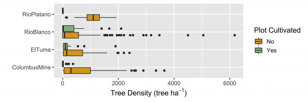
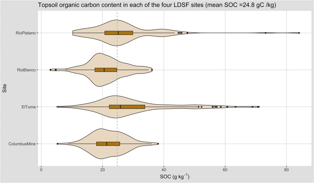
“For example, we see higher tree densities in non-eroded soil,” Winowiecki says, “and higher soil organic carbon in non-eroded landscapes.”
Most people know that forests can act as carbon sinks, but of the total carbon found in terrestrial ecosystems nearly 80 percent is actually stored in the soil. Soil carbon reservoirs are also at risk, and the team has published widely on the link between land degradation and soil organic carbon.
Furthermore, Rattan Lal, director of Ohio State University’s Carbon Management and Sequestration Center, estimates that, with cultivation, the world’s soil has lost up to 70 percent of its original carbon stock. If researchers could find a way to maximize soil organic carbon sequestration, then that would be a significant blow in our Herculean labor to reduce the amount of carbon dioxide in the atmosphere.
According to the new report, soil organic carbon levels are low across all four of the NHSL study blocks. Even small increases in soil organic carbon, when multiplied over large areas, would make a measurable difference – as well as increasing overall soil quality.
“One of the things we’re able to do now is map soil organic carbon over very large areas and look at the potential for storage of carbon in the soil,” Vågen explains.
Combining field data collected with the LDSF and remote sensing imagery from satellite, Vågen and his team are able to produce maps of key soil and land health indicators at a scale relevant to farmers and decision makers, for example at 30 meter resolution, with high accuracy (using the Landsat satellite imagery, the resolution is 30 meter squared).
“We can say what the trends are and what the potential is to store carbon in the soil,” Vågen says. “And we can do that down to the level of individual farmers.”
Of course, this information, however precise, would mean nothing at all unless the farmers could do something about it.
Winowiecki, a specialist in soil organic carbon, has good news: “With good land and landscape management we can increase soil organic carbon,” she says. “But the data shows wide variation, even within one site, so it’s important that we tailor the management to each specific farm.”
It sounds like a lot of work, but it should come as no surprise that there is no “one size fits all” solution.
“We talk a lot about ‘Options by context’,” Winowiecki says. “That means developing local options for the local context.”
Different areas can vary enormously, not only by physical environment, but also by local governance and even household structure. These factors go beyond the LDSF method and the second strand of the Sentinel Landscape approach is a socio-economic survey that attempts to capture the wider context in which the landscape is embedded.
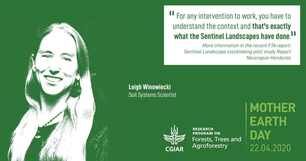
“For any intervention to work,” Winowiecki says, “you have to understand the context and that’s exactly what the Sentinel Landscapes have done.”
Context is everything
The socio-economic surveys was every bit as impressive an undertaking as the biophysical baseline study of the LDSF. The development of the socio-economic methodology and design of the household module was coordinated by Anja Gassner, while the subsequent analysis of data generated for all the landscapes was led by Brian Chiputwa (both with the Research Methods Groups at ICRAF) in consultation with CATIE.
The socio-economic surveys were designed to capture baseline information on households’ production systems, livelihood portfolios, asset endowment and use of natural resources such as forests. This data was then used to construct various indicators that can be used as proxies for household’s dependency on natural resources (land, water and forests), food security and nutrition and poverty status. These indicators can provide important insights into household economic activities.
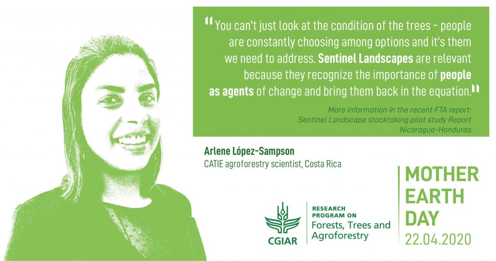
Based in Costa Rica, CATIE agroforestry scientist Arlene López-Sampson helped analyze the reams of NHSL data. “You can’t just look at the condition of the trees and ignore the people,” López-Sampson says, “because they are constantly choosing among options and it’s them we need to address. Sentinel Landscapes are relevant because they recognize the importance of people as agents of change and bring them back into the equation.”
An example of Household Module Instrument used for the NHSL household surveys [pdf]Teams of researchers spoke to 849 households in dozens of communities across the four study blocks of the NHSL, spending 3-5 days in each village, conducting interviews and workshops that explored in detail the relationship between people and landscape.
“There are a lot of people involved and we need the trust of the local municipalities and grassroots organizations,” López-Sampson says. “It’s very context dependent. What’s happening in Nicaragua is different to what’s happening in Honduras and to what’s happening in other parts of the world.”
Norvin Sepúlveda coordinated the field teams in Nicaragua and Honduras: “A combination of GIS and household data is very important to give us a better idea of what is happening,” he says. “While the GIS did the overview, we were face to face with the people, taking information directly from them.”
Sepúlveda gives a good example of how the dual approach works. “In one area, the GIS showed patches of forest left,” he says. “So we went to the household to find out why: it was to protect the water supply.”
Trees act like giant sponges, collecting and filtering rainwater before releasing it gradually into streams and rivers. Take away the trees and you get flash floods, soil erosion and a sharp reduction in water quality.
“It’s very important for us to find out why forest is left standing,” Sepúlveda says. “It often depends on a farmer’s education, on the state of his land, and on whether he has legal rights to the land.”
And so we come to the thorniest issue faced by the NHSL team: conflict and governance.
Within the socio-economic surveys, the institutional mapping and natural resource governance activities were implemented using the International Forestry Resources and Institutions (IFRI) methodology, developed by Scientists at the University of Michigan, USA.
“The one big challenge”
“The major challenge of the whole project was operating in the border,” Sepúlveda says. “Lack of governance there is the one big challenge.”
“In Nicaragua, El Tuma La Dalia is doing well with restoration, earning some extra money for coffee farmers,” Sepúlveda explains. “But at Columbus Mine, the deforestation has been very bad.”
Columbus Mine is the home of the Tasba-Pry indigenous group and, according to the report, their practice of communal land ownership, although recognized by the government, is coming into conflict with the growing population of settlers who pursue private ownership.
It is a similarly mixed story in Honduras: “At Rio Platáno they are approaching forest management, which is good,” Sepúlveda says. “But in Rio Blanco livestock is taking down all the forest that is left.”
Rio Platáno is home to several different indigenous groups, whose land rights have not been recognized by the government. As a result, the NHSL study reports, they have fallen victim to land grabs.
“We also have problems there with drug trafficking,” López-Sampson says. “It’s really hard to work in that kind of geography because it’s not only about land management; it’s also about organized criminal activities.”
But of course these kinds of challenges are not unique to the NHSL and researchers must understand the whole picture in order to change behaviors.
“We chose a combination of both different contexts and people,” Sepúlveda explains. “It makes for a contrast to the other agricultural sites, which are more stable.”
Sentinel solutions: Making change happen
The Sentinel Landscapes program is a breathtaking display of the research possible when scientists from different disciplines collaborate at every scale, from collecting soil samples on the ground to capturing remote sensing data from space to conducting focus group discussions with farmers or interviewing individual farmers on their farms.
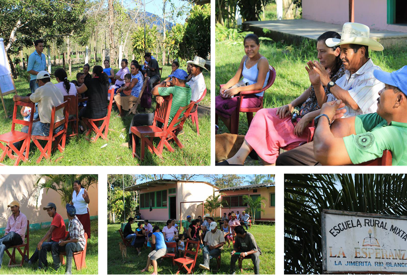
Discussion groups with farmers and local communities in Rio Blanco
“We need a lot of people to do our work,” López-Sampson says. “The coordination of knowledge is really important: between academics, but also among the local organizations who are doing all the interventions we try to promote so that we all have healthy ecosystems.”
The team hopes that the work they have done in the NHSL can help Honduras move further up that forest transition curve and encourage Nicaragua to bottom out their deforestation sooner rather than later.
“Trees are now part of the agenda,” López-Sampson says. “Trees are now seen as important to have on the farms, not only to provide timber, but as part of local community strategies to provide incomes and help maintain a healthy ecosystem by providing a link between the landscape and the agroforestry system.”
Meanwhile, Vågen is ambitious about the future: “Using LDSF we can accurately track changes over time and create bespoke interventions for specific plots and specific farmers to maximize land conservation, biodiversity and soil organic carbon capture.”
It is clear that the long term monitoring of the Sentinel Landscapes approach is absolutely necessary to bring clarity to the slow processes of landscape management and climate change.
“Five, ten years isn’t long enough,” Sepúlveda concludes. “I really hope these projects carry on, in order to see restoration, in order to see people change their minds and in order to see the new generations make change happen.”
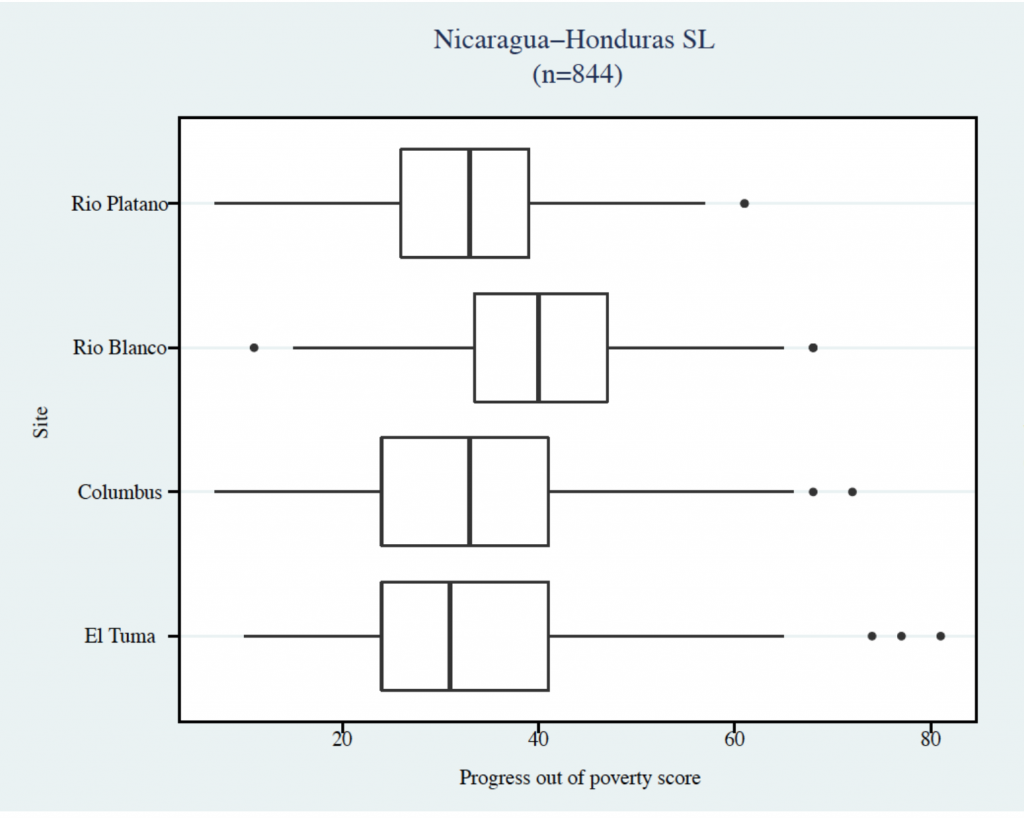
The ultimate goal of the Sentinel Landscapes approach is to build up on these diverse data over longer periods and be able to integrate the socio-economic, biophysical and political indicators. For example, with long-term data, it will be interesting to map out causal links between household poverty levels (see diagram below) and land degradation over time in the four sites; and how these vary through different governance structures across communities.
The Economist recently published an interesting report in 2017 titled “The world’s most valuable resource is no longer oil, but data”. With adequate investment and if collected in a dynamic, responsive and consistent way, big data approaches that monitor and integrate indicators from diverse disciplines such as the natural and social sciences, can lead to more complete and actionable set of insights for better adaption and mitigation strategies against climate change. Initiatives such as the SL could well be the next oil in future.
“A warning shot”: Sentinel Landscapes research and Coronavirus
At the time this article was written, all the NHSL scientists were already all working from home (be it in Costa Rica, Nicaragua or Kenya), in a global attempt to slow the transmission of coronavirus. “Our heavy reliance on industrial agriculture, with large, uniform herds, makes us vulnerable to outbreaks,” Vågen says. “The information we can provide, such as landscape diversity, could be a valuable contribution down the road.”
Vågen warns that ecological degradation makes diseases such as Covid-19 much more likely and, in our hyper-connected world, we need to start paying closer attention.
“It’s one of those up and coming things that we need to be looking at,” Vågen says. “And not just coronavirus, but other diseases,” he adds. “For me, it’s a warning shot. It’s something that we need to understand better, how it relates to the state of our planet in general.”
In times past, sentinels were flesh and blood watchers responsible at all hours to warn their kinsfolk of any approaching existential threat – whether wild beast, enemy army, fire or plague.
Today, our most valuable sentinels are scientific: the ice core samples that warn us of global heating; the remote sensing data that warn us of deforestation.
The Covid-19 outbreak shows what can happen when we have no sentinels – or, worse, when we ignore them. Without sufficient, credible warning, our society becomes extremely vulnerable to unseen existential threats.
By David Charles. This article was produced by the CGIAR Research Program on Forests, Trees and Agroforestry (FTA). FTA is the world’s largest research for development program to enhance the role of forests, trees and agroforestry in sustainable development and food security and to address climate change. CIFOR leads FTA in partnership with Bioversity International, CATIE, CIRAD, INBAR, ICRAF and TBI. FTA’s work is supported by the CGIAR Trust Fund.
Selected references
Chiputwa, B., Ihli, H.J., Wainaina, P., Gassner, A., 2020. Accounting for the invisible value of trees on farms through valuation of ecosystem services, in: Rusinamhodzi, L. (Ed.), The Role of Ecosystem Services in Sustainable Food Systems. Elsevier Inc., pp. 229–261. https://doi.org/10.1016/B978-0-12-816436-5.00012-3
Chiputwa, B. 2016. An exploratory guide on constructing socioeconomic indicators for the Sentinel Landscape Project: The case of the Nicaragua-Honduras Sentinel Landscape. Nairobi, Kenya: World Agroforestry Centre (ICRAF), 56 p. https://drive.google.com/file/d/0B8GL6bTxo5ekMXRzN003ck1hV1E/view
FTA, 2011. CGIAR Research Program 6 – Forests, Trees and Agroforestry: Livelihoods, Landscapes and Governance Proposal. Document available here
Pramova, E.; Lavorel, S.; Locatelli, B.; Colloff, M.J.; Bruley, E. 2020. Adaptation in the Anthropocene: How we can support ecosystems to enable our response to change, CIFOR. https://doi.org/10.17528/cifor/007588
Sepúlveda N, Vågen T-G, Winowiecki LA, Ordoñez J, Chiputwa B, Makui P, Somarriba E and López-Sampson, A. 2020. Sentinel Landscape stocktaking pilot study: Report Nicaragua-Honduras. Working Paper 2. Bogor, Indonesia: The CGIAR Research Program on Forests, Trees and Agroforestry (FTA). https://doi.org/10.17528/cifor/007537
Vågen, T.-G.; Winowiecki, L.A. Predicting the Spatial Distribution and Severity of Soil Erosion in the Global Tropics using Satellite Remote Sensing. Remote Sens.2019, 11, 1800. https://www.mdpi.com/2072-4292/11/15/1800
Vågen, Tor-G., Winowiecki, L., Tondoh, J.E., Desta, L.T. and Gumbricht, T. 2016. Mapping of soil properties and land degradation risk in Africa using MODIS reflectance. Geoderma. http://dx.doi.org/10.1016/j.geoderma.2015.06.023
Vågen, T-G and Winowiecki, L. 2013. Mapping of soil organic carbon stocks for spatially explicit assessments of climate change mitigation potential. Environmental Research Letters. 8. http://dx.doi.org/10.1088/1748-9326/8/1/015011
Improving livelihoods, equity and forests through sustainable management of NTFPs
Improving livelihoods, equity and forests through sustainable management of NTFPs
Notice: Undefined variable: id_overview in /home/ft4user/foreststreesagroforestry.org/wp-content/themes/FTA/template-parts/content.php on line 64
short-description
Posted by
FTA COMMUNICATIONS TEAM
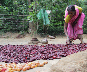
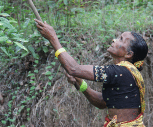
Drying the rinds of Garcinia indica, an NTFP prized in the pharmaceutical industry for its weight loss properties. Photo by E. Hermanowicz/Bioversity International
An estimated 1.6 billion people worldwide live in and around forests, and depend on them for their livelihoods. However, forest degradation and deforestation are accelerating, and endangering local livelihoods.
The careful management and conservation of biodiversity are fundamental for sustaining ecosystems and livelihoods but are increasingly difficult to achieve in contexts of persistent poverty, a growing international demand for timber and non-timber forest products (NTFP), and climate change.
Moreover, at the local level, decision-making power on management of forests and forest products, and the sharing of related costs and benefits are often inequitably distributed across groups, marginalizing people based on gender, caste, ethnicity, socioeconomic status, and other factors of social differentiation.
A new publication, Guidelines for Equitable and Sustainable Non-timber Forest Product Management, offers field-tested strategies and good practices on how to pursue the multiple goals of gender equality and social inclusion, environmental integrity, and livelihoods improvement through the sustainable use and management of non-timber forest products.
To address some of these challenges, many countries have adopted community-based or joint forest management approaches. It is increasingly recognized that gender equity and social inclusion are key components of effective and efficient forest management approaches, as well as a goal. Yet, they are also a complex challenge with deep-seated causes and effects, including poor governance, corruption, and lack of tangible and equally distributed benefits, all of which hinder sound forest management.
In their new publication, Guidelines for Equitable and Sustainable Non-timber Forest Product Management, Bioversity International scientists Riina Jalonen, Hugo Lamers, and Marlène Elias draw from their experience in two Indian districts – Mandla, in the state of Madhya Pradesh, and Uttara Kannada, in the state of Karnataka – to provide guidance on how to pursue the triple goals of gender equality and social inclusion, environmental integrity, and improved livelihoods through the sustainable use and management of NTFPs.
NTFPs are of foremost importance for rural communities living in or near forests. For example, the flower of the mahua tree (Madhuca longifolia), which is used to make a local alcohol or as an alternative to coffee in the Mandla district, or the rind of the kokum fruit (Garcinia gummi-guta) found in Uttara Kannada district, which is valued for its weight loss properties in the international pharmaceutical industry, bring important income to local households. Other NTFPs, like mangoes in the Uttara Kannada district, also play an integral role for home consumption and are important for the local food culture.
A woman uses a stick to harvest an NTFP in Karnataka, India. Photo by E. Hermanowicz/Bioversity International
The set of six good practice guidelines address some of these issues through a focus on:
Promoting collective sales of NTFPs
Fostering gender equity and inclusion in joint forest management
Achieving income generation and forest regeneration through the collection of ripe fruit
Avoiding tree damage as a result of the collection of NTFPs
Effective monitoring of forests to improve management
Restoring degraded forest landscapes through planting of valuable trees.
For example, the guideline on gender equity and social inclusion in joint forest management (JFM) details how women’s participation can improve the efficiency of JFM and lead to more gender-equal outcomes. Yet, women face time, mobility, and information constraints, as well as norms that discriminate against them in public decision-making spaces. These have to be addressed to allow them to participate meaningfully in JFM, and to make their voices heard in decision-making.
Additional constraints can be found at the intersection of gender, age, and ethnicity or caste. In the study districts, participating in JFM meetings is considered a “man’s role”, and women often feel out of place there. They are not encouraged to express their opinions, despite the fact that they have a rich knowledge of the forest. This is especially the case for women from marginalized castes or tribes, who are most dependent on, and knowledgeable about, the forest, but also most discriminated against.
The guidelines propose strategies to promote women’s participation in JFM, such as scheduling meetings at times and in places convenient for women, creating women-only spaces where women can speak their minds freely to then have their opinions brought to the JFM table, improving the flows of information towards local women.
The practical strategies proposed in the guidelines can be used by facilitators working with communities to improve their livelihoods through the sustainable and equitable use and management of NTFPs. Practitioners can use the guidelines to design and conduct community meetings that can help participants identify practices that are fitting for their context. Questions are presented in the guidelines as the basis for group discussions, which can foster participants to find and implement collective solutions to improve the state of their forests and their livelihoods.
The Guidelines for Equitable and Sustainable Non-Timber Forest Product Management were developed as part of the project ‘Innovations in Ecosystem Management and Conservation (IEMaC)’, supported by USAID India Mission, and are part of the CGIAR Research Program on Forests, Trees and Agroforestry, which is supported by the CGIAR Trust Fund.
Notice: Undefined variable: id_overview in /home/ft4user/foreststreesagroforestry.org/wp-content/themes/FTA/template-parts/content.php on line 64
Posted by
FTA COMMUNICATIONS TEAM
Robert Nasi, Director General of the Center for International Forestry Research (CIFOR), gives welcoming remarks at the Global Landscapes Forum 2018 in Nairobi, Kenya, on Aug. 29.
Notice: Undefined variable: id_overview in /home/ft4user/foreststreesagroforestry.org/wp-content/themes/FTA/template-parts/content.php on line 64
sf_publications_year
Posted by
FTA COMMUNICATIONS TEAM
The Paris Climate Agreement recognizes the importance of the mechanism to Reduce Emissions from Deforestation and forest Degradation, and enhance carbon stocks (REDD+). We reviewed 45 articles from the recent scientific literature to understand the outcomes of REDD+ interventions on the ground, in terms of local participation in REDD+, and its carbon and non-carbon (e.g. tenure, well-being, biodiversity) goals. Our review finds few studies that use a counterfactual scenario to measure REDD+ impacts, and relatively little attention to carbon (versus non-carbon) outcomes. The few studies focused on carbon/land use outcomes show moderately encouraging results, while the more numerous studies on non-carbon outcomes (especially well-being) highlight small or insignificant results. To enhance REDD+ performance, these studies recommend improved engagement with local communities, increased funding to bolster interventions on the ground, and more attention to both carbon and non-carbon outcomes in implementation and evaluation.
Notice: Undefined variable: id_overview in /home/ft4user/foreststreesagroforestry.org/wp-content/themes/FTA/template-parts/content.php on line 64
Posted by
FTA COMMUNICATIONS TEAM
After an expert panel discussion in the first part of this event, the second part saw a vibrant Q&A between the speakers: Dr. Moira Moeliono, Dr. Pham Thu Thuy, Vanessa Benn, Dr. Yuya Aye, Dr. Patricia Gallo, Javier Perla, Lemlem Tajebe and Dr. Maria Brockhaus.
Lessons learned from REDD+: progress in 8 countries and the way forward
Lessons learned from REDD+: progress in 8 countries and the way forward
24 May, 2018
Notice: Undefined variable: id_overview in /home/ft4user/foreststreesagroforestry.org/wp-content/themes/FTA/template-parts/content.php on line 64
Posted by
FTA COMMUNICATIONS TEAM
“Lessons learned from REDD+: progress in 8 countries and the way forward”, organized by the Center for International Forestry Research (CIFOR), took place in Jakarta, Indonesia, on May 9, 2018.
All over the world, REDD+ countries are struggling with the design and implementation of coherent policies and measures to reduce emissions from deforestation and forest degradation. To bring evidence on which factors and configurations are crucial to make progress will be helpful for decision-makers and practitioners at all levels involved in REDD+.
In 2012 and 2014, CIFOR, through Global Comparative Study on REDD+, examined the national political context in 13 REDD+ countries to identify the enabling conditions for achieving progress with the implementation of countries’ REDD+ policies and measures. To assess countries’ progress with REDD+, CIFOR looked at various factors, such as importance of already initiated policy change, and the availability of performance-based funding in combination with strong national ownership of the REDD+ process.
The findings show REDD+ countries are on different stages. Brazil and Guyana are among countries in incomplete progress. Although Brazil was assessed successful in REDD+ progress but they have not completely overcome path dependencies in deforestation and forest degradation (May, Millikan, & Gebara, 2011), despite the country’s investments in command and control measures (Assunc¸a˜o, Gandour, & Rocha, 2012; Maia, Hargrave, Go´mez, & Ro¨per, 2011). Guyana, with much less pressure on forest resources seems to strengthen its REDD+ path with improved institutions of forest governance and considerable progress in developing an MRV system (Birdsall & Busch, 2014), although this remains debated (Henders & Ostwald, 2013). Indonesia, after the 2015 political change, confirmed the importance of ownership over the REDD+ process if performance-based payments are supposed to make a difference. REDD+ in Indonesia has been from its beginnings a highly contested and dynamic policy arena (Indrarto et al., 2012).
Assessment on REDD+ progress in Vietnam showed a positive outcome irrespective of whether there are inclusive policy processes or not. It is important to note that ownership of the REDD+ process has reduced only recently (and seems to be regained with developments in the institutional set-up in 2015). Hence, the finding could indicate that progress is possible when donors politically and financially dominate the REDD+ process while there is political commitment to REDD+ by the government as well as by coalitions of drivers of changes. Several REDD+ countries, such as Ethiopia, are on rocky roads due to lack of ownership and performance based funding commitment, despite of efforts to make the process more inclusive. This is probably explained by the fact that Ethiopia started their REDD+ process rather recently (Bekele et al., 2015; Kambire et al., 2015).
Decision support tools for forest landscape restoration: Current status and future outlook
Decision support tools for forest landscape restoration: Current status and future outlook
06 April, 2018
Notice: Undefined variable: id_overview in /home/ft4user/foreststreesagroforestry.org/wp-content/themes/FTA/template-parts/content.php on line 64
Posted by
FTA COMMUNICATIONS TEAM
Decision-making bodies at all scales face an urgent need to conserve remaining forests, and reestablish forest cover in deforested and degraded forest landscapes. The scale of the need, and the opportunity to make a difference, is enormous. Degradation is often viewed as ‘the problem’, and restoration as ‘the solution’. But, rather than being a goal, restoration is the means to achieve many goals. Forest landscape restoration is an active, long-term process to regain ecological integrity and enhance human well-being when forest cover, forest qualities and forest-based contributions to people are diminished. Despite the many advances in the development and application of decision support tools in FLR, this review reveals a gap in tools for the implementation of landscape-scale restoration initiatives and for guiding monitoring and adaptive management. The review also reveals that available tools primarily focus on assessing restoration opportunities at a broader scale, rather than within landscapes where implementation occurs. Evidence from research on community-based conservation and forest management suggests that tools for the empowerment, land rights and capacity building of local residents can help nurture strong coalitions of landscape restoration practitioners that apply adaptive management of restoration interventions, and evaluate potential restoration scenarios in their own landscapes.
Notice: Undefined variable: id_overview in /home/ft4user/foreststreesagroforestry.org/wp-content/themes/FTA/template-parts/content.php on line 64
An agricultural landscape in Eastern Uganda. Photo by Madelon Lohbeck/ICRAF
Posted by
FTA COMMUNICATIONS TEAM
An agricultural landscape in Eastern Uganda. Photo by Madelon Lohbeck/ICRAF
Restoration has never been more important, with almost a third of the world’s land surface degraded. But what exactly is restoration? And how do we know if it works?
More than 1.5 billion of the world’s poorest people are directly affected by degraded land. The Bonn Challenge aims to have 350 million hectares restored by 2030. Private- and public-sector land managers have already promised almost half that amount. This is very encouraging but how will we even know whether the Bonn Challenge was a success? In other words: what do we mean by restoration?
One common notion is that land restoration returns an ecosystem to some previous, ideal state. Yet it is typical for degraded land to be inhabited by people, who are often among the world’s poorest and most vulnerable. Restoration has the potential to improve their livelihoods if, indeed, restoration outcomes respond to local needs. But returning to a previous state (whichever state that is) is often not feasible nor desirable. So, if restoration is to succeed in some form, it is imperative to set specific goals together with the people living on the land. Most importantly, what aspects of the functionality of the land are to be restored?
Another common notion of land restoration is that it is done through planting trees. But do we know if land is always in better shape with more trees? And what aspects of the functionality of the land can be restored with trees? Does it matter which trees?
A man records soil samples in Mwingi, Kenya. Photo by Ake Mamo/ICRAF
The study
Researchers from the World Agroforestry Centre (ICRAF) studied degraded agricultural landscapes in Kenya, Ethiopia and Uganda. Farmers suffered the consequences of degradation through declining soil fertility and crop productivity. The researchers focused on soil functions to quantify the extent to which land was degraded or restored. Instead of conducting field experiments, they looked at the variation present in the landscapes and tested whether the variation in soil functionality could be explained by vegetation cover, the number of trees, and by the traits of the trees. The study was observational and reflected the variation in real land-use practices and restoration measures actually being applied.
The researchers not only looked at the number of trees but also their size and traits to assess their impact on key ecosystem functions. This way, trees with certain traits, for instance, high wood density, could be seen to increase a certain function, such as carbon stock, more effectively than trees with low wood density. This would then give clear guidance for land-restoration planners: if the goal was to restore carbon stock then promote the use of high wood density trees.
The researchers found that in the degraded agricultural landscapes, trees were associated with more productive soils. But more important than the number of trees was the non-woody vegetation cover. With higher vegetation cover, the soil was more fertile (had higher organic carbon) and less erosion took place. In addition, the diversity of functional traits of the trees on the land was shown to enhance soil fertility; invasive species tended to increase erosion.
The results had clear implications for restoration of soil health: avoid bare ground, plant trees, prioritize the removal of invasive species and promote diversity of trees on farms. Such evidence for restoring specific ecosystem functions is urgently needed.
The study also illustrated that evidence for restoration can be found through systematic assessment of vegetation, similar to an approach common in functional ecology. Applying a trait-based approach to existing projects on land-health monitoring would allow the study of complex processes more mechanistically and would eventually generate more impact on the ground. Integrating the approach into new and existing projects would be feasible for three reasons: 1) the growing body of evidence on which traits promote which functions; 2) the large amount of freely available trait-data online; and 3) the fact that many traits are easy to measure.
‘Grain for green’: How China is swapping farmland for forest
‘Grain for green’: How China is swapping farmland for forest
Notice: Undefined variable: id_overview in /home/ft4user/foreststreesagroforestry.org/wp-content/themes/FTA/template-parts/content.php on line 64
A patchwork mountain landscape of agriculture, forestry and deforested terrain in Tianlin County, China. Photo by Nick Hogarth/CIFOR
Posted by
FTA COMMUNICATIONS TEAM
A legally protected ancient tree in Yunnan Province, China. The country’s successes in Forest Landscape Restoration are drawing attention globally. Photo by L. Putzel/CIFOR
Research draws lessons for global restoration goals.
Since 1999, China has restored forest landscapes across more than 28 million hectares of farmland and land classified as barren or degraded.
As global efforts turn to restoration as a way to mitigate climate change – led by the Bonn Challenge, with the goal of restoring 150 million hectares of deforested and degraded land by 2020, and 350 million hectares by 2030 – researchers are looking to China for lessons on how to achieve this.
A major driver of China’s success has been the ‘Conversion of Cropland to Forest Program’ (CCFP), also known as ‘Grain for Green’. The program pays farmers to plant trees on their land and provides degraded land to rural families to restore.
CCFP has so far cost more than $US40 billion, including direct payments to more than 32 million rural households. Overall, this massive program has affected the lives of 124 million people. The program is particularly important for China as 65 percent of the country’s total land area is mountainous and hilly, and a large proportion of China’s farmers live on sloping lands.
Some instructive findings have emerged from a four-year study by the Center for International Forestry Research (CIFOR) in partnership with scientists from China’s Forest Economics and Development Research Center (FEDRC). Under the research program known as SLANT – Sloping Lands in Transition – CIFOR became the first foreign organization to access data from China’s national restoration program.
“We wanted to get a better understanding of the socioeconomic and environmental benefits and impact of CCFP through its monitoring program. There is still a lot more to learn, especially about the effect of the program on a variety of ecosystem services,” says Yustina Artati, a CIFOR research officer.
A patchwork mountain landscape of agriculture, forestry and deforested terrain in Tianlin County, China. Photo by Nick Hogarth/CIFOR
RESTORING CHINA’S FORESTS
Louis Putzel, a former CIFOR scientist who led the SLANT program, says China has suffered serious consequences from deforestation in the past, and has had to implement a huge range of strategies to get trees back into the landscape.
This has included taking the approach of FLR, Forest Landscape Restoration, which aims to improve ecological functions and human well-being.
“FLR as a field has a lot to learn from China,” says Putzel.
Research collaboration through SLANT has focused on rigorous data collection and analysis, as well as support for environmental assessments. This work is helping scientists identify any research gaps, learn what works and what needs improvement.
Putzel says the development community, as well as national governments implementing reforestation projects, need to know how the approach has worked in China.
Each year, the FEDRC researchers and data investigators visit farmers annually in 21 provinces to find out firsthand the successes and also the challenges these communities face. The results can eventually help communities make more informed decisions that affect their land and livelihoods.
“We have been working with our Chinese counterparts to ensure that the data collection is the best it can be. Surveys have been done of thousands of farm families and the results can help not only China, but the global community,” says CIFOR researcher Himlal Baral.
He adds that plans are being made for further research collaboration with several other Chinese research institutions, including work with Renmin University and Beijing Forestry University on the socioeconomic and biophysical aspects of forestry, landscape restoration and climate change.
Key findings from SLANT have been shared through workshops, presentations, and key events, and of course research papers – to date, more than 70 have been published.
SHARING THE KNOW-HOW
Ethiopia is just one example of how other countries can learn from China’s success. Scientists and government forestry officials from China and Ethiopia have been brought together under the SLANT program to share experiences and find solutions to problems that can have a negative impact on reforestation programs.
Last year, Chinese researchers were able to see for themselves the challenges Ethiopia faces during a field visit and provide some FLR solutions for Ethiopia to reach its goal of restoring 15 million hectares of degraded forests.
CIFOR researchers have been working with a number of China’s national agricultural and forestry research institutes for more than 15 years, and this partnership has resulted in a rich source of information and data that can be used to improve agricultural and forestry strategies as well as rural livelihoods.
“During our long-standing collaboration with China, we have benefited from the knowledge and conceptual inputs of our Chinese colleagues on forestry-related matters as they apply in China — from bamboo enterprise value chains, to the role of forestry Chinese enterprises abroad, to more recent forest restoration,” says Robert Nasi, CIFOR’s Director General.
Nasi says this collaboration has opened the door to invaluable knowledge and data on the Chinese land restoration programs, which are among the world’s largest.
“We would like to expand to new topics with additional resources focusing on forest product value chains and forest landscape restoration considering important cross-cutting issues like tenure and climate change,” he says.
‘Grain for green’: How China is swapping farmland for forest
‘Grain for green’: How China is swapping farmland for forest
13 December, 2017
Notice: Undefined variable: id_overview in /home/ft4user/foreststreesagroforestry.org/wp-content/themes/FTA/template-parts/content.php on line 64
A patchwork mountain landscape of agriculture, forestry and deforested terrain in Tianlin County, China. Photo by Nick Hogarth/CIFOR
Posted by
FTA COMMUNICATIONS TEAM
A legally protected ancient tree in Yunnan Province, China. The country’s successes in Forest Landscape Restoration are drawing attention globally. Photo by L. Putzel/CIFOR
Research draws lessons for global restoration goals.
Since 1999, China has restored forest landscapes across more than 28 million hectares of farmland and land classified as barren or degraded.
As global efforts turn to restoration as a way to mitigate climate change – led by the Bonn Challenge, with the goal of restoring 150 million hectares of deforested and degraded land by 2020, and 350 million hectares by 2030 – researchers are looking to China for lessons on how to achieve this.
A major driver of China’s success has been the ‘Conversion of Cropland to Forest Program’ (CCFP), also known as ‘Grain for Green’. The program pays farmers to plant trees on their land and provides degraded land to rural families to restore.
CCFP has so far cost more than $US40 billion, including direct payments to more than 32 million rural households. Overall, this massive program has affected the lives of 124 million people. The program is particularly important for China as 65 percent of the country’s total land area is mountainous and hilly, and a large proportion of China’s farmers live on sloping lands.
Some instructive findings have emerged from a four-year study by the Center for International Forestry Research (CIFOR) in partnership with scientists from China’s Forest Economics and Development Research Center (FEDRC). Under the research program known as SLANT – Sloping Lands in Transition – CIFOR became the first foreign organization to access data from China’s national restoration program.
“We wanted to get a better understanding of the socioeconomic and environmental benefits and impact of CCFP through its monitoring program. There is still a lot more to learn, especially about the effect of the program on a variety of ecosystem services,” says Yustina Artati, a CIFOR research officer.
A patchwork mountain landscape of agriculture, forestry and deforested terrain in Tianlin County, China. Photo by Nick Hogarth/CIFOR
RESTORING CHINA’S FORESTS
Louis Putzel, a former CIFOR scientist who led the SLANT program, says China has suffered serious consequences from deforestation in the past, and has had to implement a huge range of strategies to get trees back into the landscape.
This has included taking the approach of FLR, Forest Landscape Restoration, which aims to improve ecological functions and human well-being.
“FLR as a field has a lot to learn from China,” says Putzel.
Research collaboration through SLANT has focused on rigorous data collection and analysis, as well as support for environmental assessments. This work is helping scientists identify any research gaps, learn what works and what needs improvement.
Putzel says the development community, as well as national governments implementing reforestation projects, need to know how the approach has worked in China.
Each year, the FEDRC researchers and data investigators visit farmers annually in 21 provinces to find out firsthand the successes and also the challenges these communities face. The results can eventually help communities make more informed decisions that affect their land and livelihoods.
“We have been working with our Chinese counterparts to ensure that the data collection is the best it can be. Surveys have been done of thousands of farm families and the results can help not only China, but the global community,” says CIFOR researcher Himlal Baral.
He adds that plans are being made for further research collaboration with several other Chinese research institutions, including work with Renmin University and Beijing Forestry University on the socioeconomic and biophysical aspects of forestry, landscape restoration and climate change.
Key findings from SLANT have been shared through workshops, presentations, and key events, and of course research papers – to date, more than 70 have been published.
SHARING THE KNOW-HOW
Ethiopia is just one example of how other countries can learn from China’s success. Scientists and government forestry officials from China and Ethiopia have been brought together under the SLANT program to share experiences and find solutions to problems that can have a negative impact on reforestation programs.
Last year, Chinese researchers were able to see for themselves the challenges Ethiopia faces during a field visit and provide some FLR solutions for Ethiopia to reach its goal of restoring 15 million hectares of degraded forests.
CIFOR researchers have been working with a number of China’s national agricultural and forestry research institutes for more than 15 years, and this partnership has resulted in a rich source of information and data that can be used to improve agricultural and forestry strategies as well as rural livelihoods.
“During our long-standing collaboration with China, we have benefited from the knowledge and conceptual inputs of our Chinese colleagues on forestry-related matters as they apply in China — from bamboo enterprise value chains, to the role of forestry Chinese enterprises abroad, to more recent forest restoration,” says Robert Nasi, CIFOR’s Director General.
Nasi says this collaboration has opened the door to invaluable knowledge and data on the Chinese land restoration programs, which are among the world’s largest.
“We would like to expand to new topics with additional resources focusing on forest product value chains and forest landscape restoration considering important cross-cutting issues like tenure and climate change,” he says.
Can REDD+ help Brazil roll back rising deforestation rates?
Can REDD+ help Brazil roll back rising deforestation rates?
Notice: Undefined variable: id_overview in /home/ft4user/foreststreesagroforestry.org/wp-content/themes/FTA/template-parts/content.php on line 64
Posted by
FTA COMMUNICATIONS TEAM
A site of deforestation is seen from the air in Brazil. Photo by CIFOR
In Brazil, the role of REDD+ in stemming deforestation since 2004 is unclear — as is its potential for reversing the recent upward trend.
Land-use change represents more than 60 percent of Brazil’s greenhouse gas (GHG) emissions, and the Amazon accounts for 65.2 percent of that amount, according to government figures, although those numbers are sometimes contested. Much of the deforestation in the country stems from the promotion of private enterprises, particularly ranching, timber and mining.
Since the 1980s, Brazil has taken steps to reduce deforestation, with the greatest success occurring between 2004 and 2016, when the rate decreased by 71 percent. Some of those measures involved actions for reducing emissions from deforestation and forest degradation (REDD+).
Whether that improvement will be sustainable in the long run is unclear, however, as there was a recent sharp increase in deforestation rates.
This third edition provides a fully updated overview of conditions affecting environmental policy for REDD+ in the Brazilian Amazon through 2015, when Brazil submitted its National REDD+ Strategy (ENREDD+) to the UN Framework Convention on Climate Change (UNFCCC).
How did Brazil slow deforestation?
Reducing deforestation became a Brazilian government priority even before international climate agreements incorporated REDD+ schemes for reducing GHG emissions caused by deforestation and forest degradation. International scrutiny, combined with pressure from Amazonian rubber tappers who make their living from the forest, led successive governments to tackle the problem, albeit with limited success.
In 2003, Brazil submitted a proposal for “compensated reduction” under the UNFCCC, calling for compensation by developed countries for less-developed countries that reduce greenhouse gas emissions related to land-use change in tropical forests and promote sustainable land management.
Over the next dozen years, a combination of incentives and disincentives to keep the forest standing and more effective law enforcement through command and control measures led to a dramatic drop in deforestation, especially in the “deforestation arc” around the southern and southeastern edge of the Amazon.
An aerial view of the Amazon rainforest is seen near Manaus, the capital of the Brazilian state of Amazonas, Brazil. Photo by Neil Palmer/CIAT for CIFOR
In 2015, Brazil officially submitted its National REDD+ Strategy to the UNFCCC. By then, many REDD+ pilot initiatives and related policies had already been implemented.
There are several clear reasons for Brazil’s success in decreasing deforestation.
First, the country’s sophisticated monitoring system provides real-time information about land use change to Brazil’s environmental enforcement agency, the Brazilian Institute of Environment and Renewable Natural Resources (IBAMA). This has reinforced command and control measures on the ground.
Meanwhile, reduction of deforestation became policy with the Action Plan to Prevent and Control Deforestation in the Amazon (PPCDAm), whose implementation began in 2004. The designation of several protected areas between 2002 and 2010, alongside new policies in 2007 and 2008 that targeted a “federal blacklist” of municipalities with critical deforestation rates, were crucial in reducing unprecedented levels of deforestation.
Finally, a series of demand-side measures (including multi-stakeholder round tables, zero-deforestation agreements and trade embargoes) began playing a key role in slowing deforestation.
But the problem is reemerging. Current deforestation rates in the Amazon are the highest in the past four years.
Between August 2014 and July 2015, Brazil clear-cut 6,207 square kilometers, a 24 percent increase over the previous period. Amid turbulent political events, national policy is now moving in the opposite direction, including several new constitutional amendments that threaten forests and the environment.
The Forest Law passed in 2012 granted amnesty to landowners who deforested illegally before 2008. Meanwhile, a measure requiring farmers to register rural properties and restore or provide compensation for illegally-deforested areas has been delayed twice.
Proposed Constitutional Amendment (PEC) 215 would require Congress to approve the demarcation of indigenous lands, while Constitutional Amendment (PEC) 65 would facilitate licensing of major infrastructure projects without adequate evaluation and mitigation of environmental impacts. That is of particular concern, because of proposals to build 334 dams throughout the Amazon Basin.
More than one million square kilometers of the Brazilian Amazon have also been registered for mining, which would threaten forests.
Meanwhile, the number of conservation units in the Amazon has been reduced, leading to an increase in illegal occupation, while a lack of financial resources is hampering on-site monitoring of deforestation.
And much of the deforestation has shifted to the Cerrado, a tropical savanna ecosystem east of the Amazon, which is now under enormous pressure, but receives far less attention than the Amazon forest.
Until recently, the Cerrado was not considered in REDD+ programs or other policies for combating deforestation, and it remains to be seen whether new policies will successfully address the land-use-change challenges there.
REDD+ strategy still at an early stage
Brazil’s National REDD+ Strategy, known as ENREDD+, is aimed at reducing illegal deforestation; conserving and restoring forest systems; and generating economic, social and environmental co-benefits.
The strategy calls for more monitoring and for convergence among policies (climate, forests and biodiversity) by 2020, as well as increased financing and benefit-sharing for REDD+ strategies.
ENREDD+ will be guided by the National Policy for Climate Change and the Forest Code. It identifies three sectoral plans as the primary channels for implementing REDD+: PPCDAm; the Action Plan to Prevent and Control Deforestation and Fire in the Brazilian Cerrado (PPCerrado); and the Plan for Low Carbon Agriculture (ABC).
The Amazon rainforest is pictured in the Brazilian state of Amazonas. Photo by Neil Palmer/CIAT for CIFOR
The strategy supplements these plans with cross-cutting measures, including a financial architecture for REDD+ and a set of safeguards designed to ensure that REDD+ actions do not inflict social or environmental harm.
It is not yet clear, however, what types of measures Brazil will concentrate on to implement REDD+, coordinate national and sub-national efforts, and guarantee that safeguards are in place. Detailed regulation of these issues was left to the National REDD+ Entity and its Thematic Consultation Chambers, which are still in the early stages of designing specific principles and procedures.
And evidence is still scant about the potential of sub-national initiatives to reduce deforestation, with little coordination demonstrated among the initiatives.
As a result, disagreements between federal and state government agencies and a lack of definition regarding financing, benefit-sharing and safeguards for local initiatives pose significant obstacles to implementation of ENREDD+.
There is an urgent need for stakeholders at all levels to join forces to ensure a more appropriate structure and strategy for the National REDD+ Entity and its Thematic Consultation Chambers and to clarify how ENREDD+ will be put into practice.
Policies must prevent backsliding
Although Brazil has reduced emissions in recent years, it is difficult to determine how much of this was due to REDD+ initiatives. Besides analyzing performance indicators for results at each phase of REDD+, this would require an assessment of co-benefits, such as improved forest governance and poverty reduction.
REDD+ was supposed to provide benefits that would overcome the limitations of “command and control” measures. Instead, however, the ENREDD+ is mainly based on government policies and previous national efforts to reduce deforestation, such as increasing monitoring and reinstating old practices of forest conservation.
It is difficult to imagine how much of the remaining “residual” deforestation can be curbed through increased command and control, especially considering the recent opening of the Brazilian beef market to the US and China.
In its REDD+ interventions, Brazil should strive for a clearer understanding of the fundamental processes and practices that drive deforestation, such as the growing extra-local and international demand for forest and agricultural commodities, subsidies from outside the forest sector that encourage the production of such commodities, and the multifaceted and evolving issues of the different actors that are the target of these incentives. ENREDD+ has yet to clarify the role of these actors, especially the private sector.
These tasks are crucial to ensure that Brazil does not turn back the clock on its battle against deforestation.
Managing degraded forests, a new priority in the Brazilian Amazon
Managing degraded forests, a new priority in the Brazilian Amazon
21 June, 2017
Notice: Undefined variable: id_overview in /home/ft4user/foreststreesagroforestry.org/wp-content/themes/FTA/template-parts/content.php on line 64
Posted by
FTA COMMUNICATIONS TEAM
Overview
By taking drastic steps, Brazil has succeeded in reducing the annual deforestation rate for Amazonia from 27 770 km2 in 2005 to 5 830 km2 in 2015. However, those steps have not had any effect on forest degradation, notably the partial destruction of the canopy.
In the Brazilian Amazon, degraded forests dominate the landscape along pioneer fronts. The region now faces a major challenge: stopping degradation and managing its forests sustainably. In this issue of Perspective, researchers highlight four priorities for research: developing degraded forest characterization and monitoring methods, drafting specific management plans, understanding the role played by all social players, and supporting policies on a territorial level.
Nowadays, degraded forests are a forest category in their own right. They could play a major role in mitigating climate change. They could also contribute to better ecological functioning on a territorial level. Drafting policies with the dual aim of reducing degradation and optimizing these forests requires strong support from research.
ICRAF explores why people matter and jelutung holds promise for Indonesia's peat
ICRAF explores why people matter and jelutung holds promise for Indonesia’s peat
Notice: Undefined variable: id_overview in /home/ft4user/foreststreesagroforestry.org/wp-content/themes/FTA/template-parts/content.php on line 64
A man plants jelutung amid other crops in a young oil-palm plantation. Photo by Robert Finlayson/ICRAF
Posted by
FTA COMMUNICATIONS TEAM
A peatland farming family poses for a portrait in Jambi, Indonesia. Photo by Robert Finlayson/ICRAF
Better management of Indonesia’s vast peatlands, some of the biggest and most efficient carbon stores on the planet, which have been extensively degraded, means working with the people who make their living from them.
A representative panel organized by the World Agroforestry Centre (ICRAF) at the Global Landscapes Forum: Peatlands Matter, a CGIAR Research Program on Forests, Trees and Agroforestry (FTA)-related event held on May 18, 2017, in Jakarta, Indonesia, discussed the challenges and successes of improving the management of peatland in the country.
Indonesia has suffered massive economic, environmental and health losses owing to fires that annually ravage peatland and from general poor management of the unique landscapes.
Slamet Supriyadi (left) speaks on stage beside Atiek Widayati. Photo by Robert Finlayson/ICRAF
By way of background, Slamet Supriyadi, a farmer from Jambi province, provided firsthand testimony about how he had cleared peat forest and then planted oil palm, jelutung (Dyera polyphylla, a once-widespread, indigenous tree that produces a latex that was formerly the main ingredient in chewing gum), coconut and coffee.
“We were eventually reprimanded by the government,” he said, “because the land status was ‘protection forest’. We were in conflict with the local forestry office, which intimidated us but through negotiations facilitated by ICRAF we were able to understand each other. We stopped trying to blame each other.
“We understood we were wrong and yet the government wouldn’t evict us because we had explained to them that our livelihoods depended on the peatland. So the government came up with a solution: they told us they needed to preserve the land and that we had to comply with the regulations, such as planting certain kinds of trees like mango (Mangifera indica), durian (Durio zibethinus), jelutung and nutmeg (Myristica fragrans).
“ICRAF helped us obtain a Community-based Forest Management (Hutan Kemasyarakatan/HKm) permit. So now we are very happy and comfortable, at least for the time being. We’ve been there since 1997.”
Workers prepare to transport oil-palm fruit. Photo by Robert Finlayson/ICRAF
FTA scientist Atiek Widayati, leader of the Securing Ecosystems and Carbon Benefits by Unlocking Reversal of Emissions Drivers in Landscapes project (2013–2015) that was funded by the Norwegian Agency for Development Cooperation, confirmed the testimony of Supriyadi from the project’s own participatory research, part of which included the facilitation of the negotiations mentioned.
The overall aim of the project in Indonesia was to assist the Tanjung Jabung Barat district government and farmers to find land-use options that would reduce greenhouse-gas emissions and also improve their livelihoods.
The situation described by Supriyadi was a common one, Widayati said, with its roots as far back as the 1970s and the beginnings of Indonesia’s transmigration schemes that shifted people from densely-populated islands to work on plantations and open new land for smallholding agriculture.
“The communities saw the land as wasteland that they could use as they liked,” she explained. ‘They occupied the fringes of peat forests, dug drainage ditches and grew cash crops like coconut to make a living. This shows that agriculture on peatland can transform livelihoods positively. The challenge comes with disasters like the fires and the over-use of peatland.
“These days, commodity crops have to be in line with sustainable-practice principles and we need to protect peatland communities’ welfare through strengthening markets and the capacities of farmers, building trust and accepting that they did not mean to violate the law.”
“Communities in Sumatra had already planted jelutung with other forest-tree types,” she explained.
“This had also been happening in Central Kalimantan. The problem at the moment is that there is a limited market for jelutung latex so it is important to rebuild it to motivate farmers to plant more of the species. They also need support in how to manage the tree and process the latex. This knowledge was lost from the last generation.
“Rehabilitation of degraded peatland isn’t just about planting trees, however, but can include using the drainage canals to farm fish so that communities can have more products from which they benefit and which will encourage them to maintain the rehabilitated areas well.”
The moderator of the discussion, FTA scientist Ingrid Öborn, ICRAF’s regional coordinator for Southeast Asia, noted that these examples showed that farmers and governments can collaborate and create a synergy in which people work in their own interest yet produce mutual benefits.
There was, moreover, a large potential to magnify this kind of cooperation by taking advantage of the extensive canal systems that were originally designed to drain the peat (and which led to it being more prone to burning) and other waterbodies.
Sri Dewi Titisari, head of the Marine and Fisheries Office of South Sumatra province, pointed out that South Sumatra alone had 17 districts and 2.5 million hectares of canals, rivers, ponds, lakes and marshes scattered throughout them.
“In peatland,” she said, “we already have canals and we plan to manage them so that the pH can be around 7–8 because if a canal isn’t prepared properly and isn’t linked to tidal or river movements then the pH is too low at 2.8 or 3; it’s too acidic. We want to apply technology so that those canals can become fish farms. In South Sumatra, we have 233 native fish species but if the water is too acidic we couldn’t even farm them let alone exotic species.”
To assist, the Ministry of Marine Affairs and Fisheries established a Southeast Asian fisheries development center in South Sumatra that is operating pilots of ‘fish forests’ or ‘silvi-fishery’ in canals that are at least 500 meters from a river or coastline so as not to disturb riverine vegetation or mangrove systems.
Newly cleared peatland is seen beside remnant ‘protection’ forest in Jambi. Photo Robert Finlayson/ICRAF
“There are things we must observe,” she cautioned, “such as choosing canals and ponds that are adjacent to communities so that they can manage the fisheries and use the products for household consumption, for food and nutrition security.
“This is a collaboration between the departments of fisheries and forestry in developing products that will benefit the communities. There is big potential because as well as processing into salted and dried products they could be consumed fresh locally as well as exported. We have been testing various technologies with the private sector and others and, hopefully soon, our local delicacies will be providing revenues for communities and the state.”
Aulia Perdana, a market specialist with ICRAF, confirmed that rewetting peatland as a critical part of rehabilitating it and maintaining its function as a carbon store did offer market opportunities as mentioned by the previous speakers.
“The jelutung market does have opportunities,” he explained. “A company in Central Kalimantan is working on development for sales to chewing-gum manufacturers in Singapore and Japan that are searching for edible gums, especially from jelutung in Indonesia. Production in Jambi and other provinces has fallen a lot but the demand is increasing for chewing gum made from natural ingredients. Similarly, gemor (Alseodaphne sp), a tree that is used in the production of mosquito coils, has enjoyed a revival of interest owing to an increase in demand for natural repellents.”
Other peatland products, such as rattan, sago and nypa palm (Nypa fruticans), also showed promise for further development, he said.
In conclusion, the moderator reiterated that while there were many challenges, from the nature of the peatland itself through to the markets for its products, the panelists had demonstrated that were many opportunities for them to be overcome through continuing and expanding collaboration between farmers, governments and the private sector.
This work forms part of the CGIAR Research Program on Forests, Trees and Agroforestry (FTA). We thank all donors who support research in development through their contributions to the CGIAR Fund.
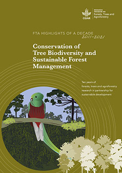


_credits Riina Jalonen")